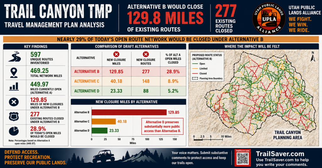


Trail Canyon TMP (Kanab) – Comments opened June 22 and are open till July 22, 2026. The Trail Canyon Travel Management Area (TMA) is located in Kane County, Utah. It is bounded by the Dixie National Forest on the north, U.S. Hwy 89 on the east, the Utah-Arizona border on the south, and Zion National Park on the west. There are 129 miles of routes proposed for new closures in Alternative B out of 450 miles of routes currently open, that’s 29% unless we take action. BLM is having trouble with their Interactive Map, and I want to start examining the trails in detail, so I created GPX files you can upload into OnX or Gaia you can get at the link below.
-
- For a complete analysis about the impacts of this plan, visit our Trail Canyon Travel Plan Analysis
-
Comments can be submitted on the BLM EPlanning website listed below or emailed to blm_ut_kn_mail@blm.gov
-
Trail Canyon Project Website and Participate Now Button
-
Draft EA for Project DOI-BLM-UT-P020=2026-0003-EA
- NEW!!!!Trail Canyon Alternative B New Closures GPX Files for OnX or Gaia Uploads
- Trail Canyon Interactive Map-Great Tool for Finding Routes Affected
-
Trail Canyon BLM Route Reports
-
Link to UPLA TrailSaver to form substantive comments by just answering a few questions about each trail.
-
If you have questions or comments, please email Loren Campbell
UPLA created an analysis tool to give a high level overview of the various travel management plan alternatives. In the analysis, you’ll find a complete list of all the routes sorted by Route number (with common names where we have them), another tab shows the Alternative B closures, and then a Top Priority page that shows the largest impacts based on mileage. It should be noted that there are many other factors that may be more important such as connectivity to other routes and other important features on the route.
You can download the complete report here or just tap on the following summary