96

ACTION ALERT-TrailSaver Revisions, Vernal and Kanab Travel Plans Updated for Comments

Specifically Intended for *{{Formal Name}}*

TrailSaver Completely Revised-Learn About The Changes

Play 
<!--

For decades, travel management planning has largely operated under policies that encouraged agencies to focus on restrictions, closures, and route reductions. Today, there is a new attitude toward public land access coming from the highest levels of government. Recent policy changes have made it clear that access, recreation, multiple use, and public enjoyment of our lands are once again important priorities, but it won't happen without you.

To take maximum advantage of these changes, we revised TrailSaver to make it easier to use and more effective. Watch our 3 minute video to learn how it works, then use TrailSaver to write your comments for Vernal and Kanab TMPs. 

Click Here For Info on Trail Canyon near Kanab
Click Here for Info on Dino North near Vernal

Dino North (Vernal) Offers Opportunity to Reopen 400 Miles of Routes

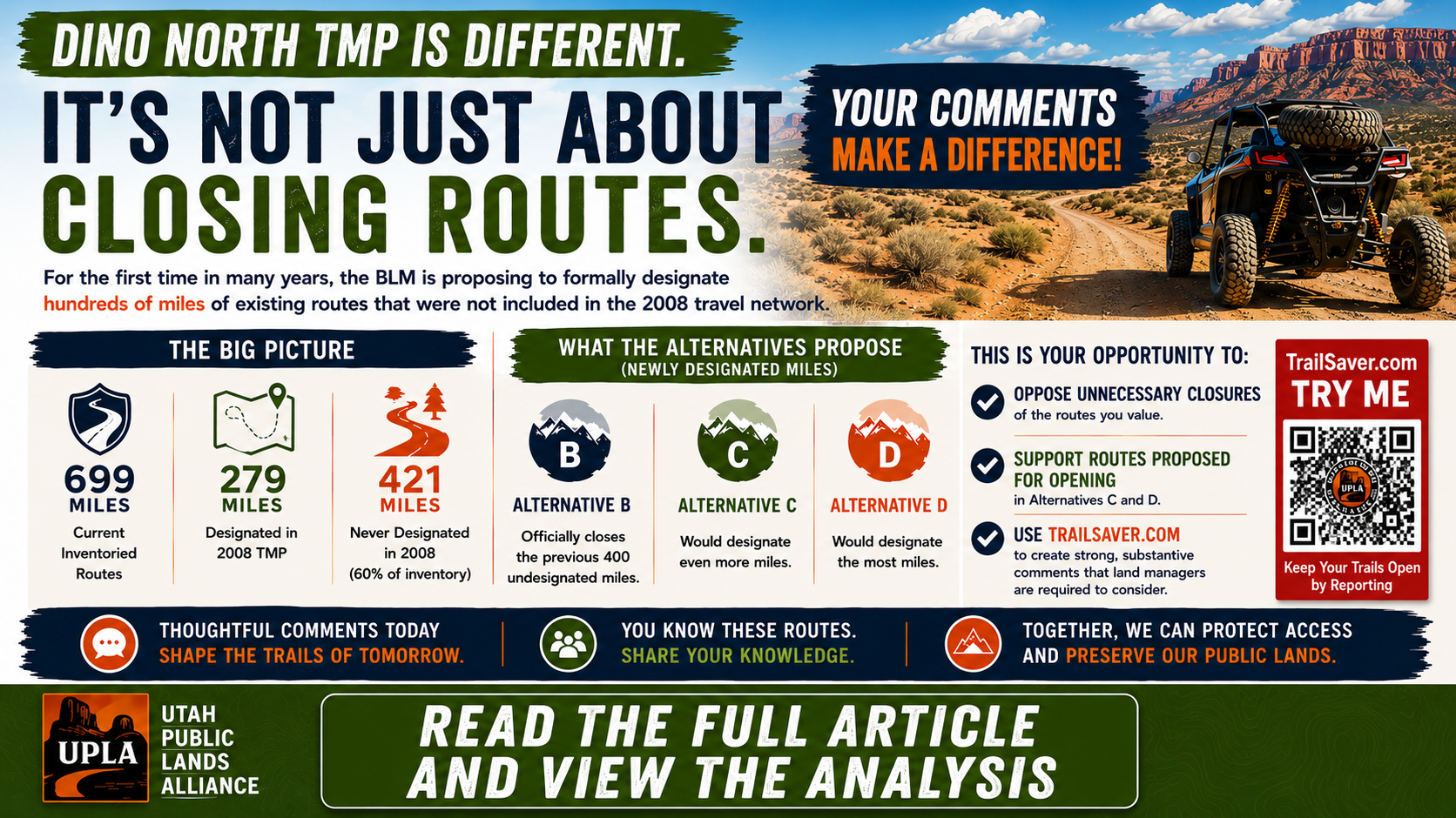
Dino North Travel Management Plan: A Different Kind of Travel Plan

For years, Utah Public Lands Alliance has argued that Travel Management Plans should not become exercises in simply reducing motorized access. If routes exist on the ground, serve a public purpose, and can be managed responsibly, they deserve an honest evaluation—not automatic closure.

The Draft Dinosaur North Travel Management Plan is different.

Unlike many recent travel plans that focused primarily on reducing access, the Dinosaur North proposal evaluates an existing transportation network that is far larger than the routes designated in the 2008 Vernal Resource Management Plan.

Our analysis of the Draft Environmental Assessment shows that the current inventoried route network contains approximately 700 miles of existing routes, yet only 279 miles were formally designated in the 2008 Travel Management Plan. That means roughly 421 miles—about 60 percent of today’s inventoried network—were never officially designated for motorized use in 2008. The Draft EA explains that those undesignated routes are treated as closed under Alternative A because they were never formally evaluated or designated. That makes Dinosaur North fundamentally different from most recent Travel Management Plans

Click Here to Learn More About Why This is so Important

Trail Canyon (Kanab) Travel Management Plan is Now Open-Save 129 Miles (29%) of Trails With Your Comments

The Trail Canyon (Kanab) Travel Plan is Now Open. Alternative B proposes closing 129 miles of routes, that's 29% of the available trails. Included in the closure proposals are the Barracks Trail, Hell Dive Canyon, and Poverty Wash. Learn all the details and help us save Trail Canyon from a devastating loss.

Click Here to Learn The Details and Help us Save Trail Canyon

Our Contact Information
*{{Organization Name}}*
*{{Organization Address}}*
*{{Organization Website}}*

Send Us a Message

You are being sent this email because you are a subscriber.
If you wish to update your Email Preferences or Unsubscribe, click *{{Unsubscribe}}*