Bears Ears National Monument (BENM) is an exquisitely beautiful and unique 1.36-million-acre gem of public land, located in Southern Utah. BENM is currently going through resource management planning following recent expansion of the monument by presidential proclamation. For more details on the monument expansion, history of BENM, and discussion of resource management planning versus travel management planning for public lands, check out our recent articles on these topics on the Utah Public Lands Alliance (UPLA) website.
The proposed Resource Management Plan (RMP) for BENM was developed via collaboration of the Bureau of Land Management (BLM), US Department of Agriculture’s Forest Service (FS), and the Bears Ears Commission (a group representing six Native American tribes). The RMP includes five Alternatives for public comment. All five Alternatives will result in detrimental impact on outdoor recreation access in BENM. Thus, we urge our members and other outdoor recreation enthusiasts to take advantage of the public comment period to advocate for preservation of recreation access. In this article, we’ll compare the varied levels of impact across the five Alternatives. The deadline to submit public comments is June 11, 2024.
The common thread through all five proposed Alternatives in the BENM RMP is: recreation access is viewed as a threat to preservation of natural and cultural resources. Rather than evaluate how recreation can be managed to prevent and mitigate potential impacts on natural and cultural resources, closed or restricted access is the dominant strategy utilized. Unique characteristics of each alternative include:
- ALTERNATIVE A: this is the “no action” alternative by which (most) existing management would continue.
- BLM lands: eight special recreation management areas (SRMAs) and two extensive recreation management areas (ERMAs) would remain intact.
- Forest Service lands: management based on Recreation Opportunity Spectrum (ROS) categories of primitive, semi-primitive non-motorized, semi-primitive motorized, and roaded natural.
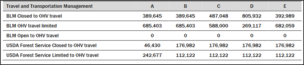
- Travel management (OHV): existing designated OHV routes would remain open (see table below)
- 928,080 open to limited OHV access
- 436,075 acres closed to OHV access
- Areas of Critical Environmental Concern (ACECs): existing ACECs would remain in place, no new ACECs would be created
- Recreational shooting: permitted
- Recreational facilities: existing facilities would remain open and intact
- ALTERNATIVE B: provides the most permissive management for recreation access considerations. However, conservation is still heavily prioritized over recreation and public access.
- BLM lands: would be managed through four SRMAs and four ERMAs
- Forest Service lands: same as Alternative A
- Travel Management (OHV):
- 797,525 acres open to limited OHV access
- 566,627 acres closed to OHV access
- Travel Management (aircraft): landings and takeoffs would be limited to Bluff Airport and Fry Canyon Airstrip, with the potential for additional locations to be identified in future implementation level decisions.
- ACECs: BLM would designate the Indian Creek ACEC, Lavender Mesa ACEC, and Valley of the Gods ACEC. The San Juan River ACEC and Shay Canyon ACEC would not be designated as ACECs.
- Recreational shooting: permitted generally, with the exception of closures in the Indian Creek Corridor Recreation Management Zone (RMZ), San Juan River SRMA, and prohibitions in campgrounds, developed recreation facilities, climbing areas, existing and designated trails, parking areas, trailheads, across roadways, rock ES-7 writing sites, and structural cultural sites. If problems with recreational shooting occur in the future, the BLM would consider future restrictions or closures.
- Recreational facilities: may be developed as needed
- ALTERNATIVE C: similar to Alternative B, with additional restrictions to use of drones
- BLM lands: same as Alt B
- Forest Service lands: same as Alt A
- Travel Management (OHV):
- 700,122 acres open to limited OHV access
- 664,030 acres closed to OHV access
- Travel Management (unmanned aircraft / drones): use of drones eliminated throughout most of BENM, with case-by-case exceptions through a permitting process
- ACECs: same as Alt B
- Recreational shooting: same as Alt B
- Recreational facilities: limited development of facilities with emphasis on maintaining natural conditions across the landscape
- ALTERNATIVE D: severe restrictions to recreation access; the primary management priority is for landscape conservation that is achieved through eliminating or heavily restricting recreation
- BLM lands: managed through creation of seven Management Areas
- Forest Service lands: same as Alt A
- Travel Management (OHV):
- 381,239 acres open to limited OHV access
- 982,914 acres closed to OHV access
- Travel Management (aircraft): same as Alt B
- Travel Management (unmanned aircraft / drones): same as Alt C
- ACECs: BLM would designate the Indian Creek ACEC, Lavender Mesa ACEC, Valley of the Gods ACEC, John’s Canyon Paleontological ACEC, and Aquifer Protection ACEC. The San Juan River ACEC and Shay Canyon ACEC would not be designated as ACECs.
- Recreational shooting: same as Alt B
- Recreational facilities: minimized development of recreational facilities and management in favor of emphasizing natural conditions
- ALTERNATIVE E (the preferred alternative): most recreation access eliminated throughout BENM; maximizes the considerations and use of Tribal perspectives on managing the landscape; emphasis is on resource protection and the use of Traditional Indigenous Knowledge and perspectives on the stewardship of the landscape.
- BLM & Forest Service lands: SRMAs and ERMAs would be eliminated; recreation managed based on a zoned approach. Four zones would be designated: Front Country, Passage, Outback, and Remote.
- Travel Management (OHV):
- 794,181 acres open to limited OHV access
- 569,971 acres closed to OHV access
- Travel Management (aircraft): same as Alt B
- Travel Management (unmanned aircraft / drones): same as Alt C
- ACECs: all existing ACECs would be carried forward, the John’s Canyon Paleontological ACEC and Aquifer Protection ACEC would also be designated.
- Recreational shooting: eliminated in full throughout all of BENM
- Recreational facilities: development allowed only in Front Country and Passage zones, when deemed an absolute necessity
As you can see from the management guidelines proposed by each alternative, there is no alternative that is pro-recreation. A pro-recreation alternative would retain all existing recreation opportunities in the monument as open, including all currently designated motorized routes. It is critical to emphasize that management by closure is not management; rather, this method of “management” serves to banish the public from the opportunity to access and enjoy our public lands. There are many effective strategies to manage public lands, including BENM, by means other than road closures, activity bans, group size limits, and exclusion zones.
We encourage outdoor recreation enthusiasts to submit comments on this RMP to advocate for a pro-recreation alternative that would involve active management techniques such as constructing new infrastructure to sustainably handle increased visitation; this would include new trails, trailheads, parking areas, bathroom facilities, campgrounds, etc. It is possible to manage the natural landscape in a manner that conserves the land, protects wildlife habitat, and retains the rugged, wild characteristics of the landscape, while also creating appropriate places, structure, and guidelines for humans to access, enjoy, and recreate throughout the land.
For more details about the BENM RMP, along with guidance on how to write a high-impact comment to submit for the public comment period, join us for a webinar on May 30 at 6:30pm MT. Utah Public Lands Alliance and BlueRibbon Coalition are partnering to share about how the RMP will affect OHV and outdoor recreation access. Tips and best practices will be presented to help you craft your own substantive comment. Click this link to register for the webinar.
For more details about the Bears Ears National Monument RMP, check out the RMP planning website, the draft RMP, and the BLM’s press release and invitation for public comment:
UPLA is continuing to review the draft RMP and seek guidance from the outdoor recreation community to identify areas of concern regarding the impacts of each proposed Alternative If you have questions or would like to share your input on the draft RMP, please contact UPLA’s Natural Resources Consultant, Rose Winn, at rose@uplapla.com.