Only You Can Keep Our Moab Trails Open

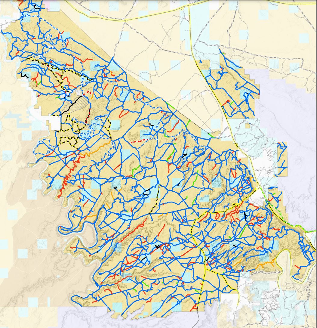
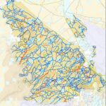
All These Trails In Red Could be Closed Without your Help

The BLM is reviewing their 2008 Travel Management Plan for the Gemini Bridges/Labyrinth area as a result of a 2017 settlement with SUWA. It should be noted as a preface that in the original 2008 TMP, 766 miles of trails were already closed

The proposal for the new TMP affects the holy grail for off roaders, and affects trails northwest of Moab from West of Highway 91 to Green River. This is a huge area, and trails that would be affected by these plans include Hey Joe Canyon, Ten Mile Canyon, Hell Roaring Canyon, Golden Spike, Gold Bar Rim, Rusty Nail, Day Canyon Point, Dead Man Point, Bull Canyon, 3D/Mashed Potatoes Jeep trails, Dead Cow and Tubes motorcycle trails are being proposed for closure. Parts of Where Eagles Dare, Buttes and Towers, Wipe Out Hill, and 7 Mile Rim also will be potentially closed to OHV use.

You must take action to prevent this happening. If you don’t participate, you are giving up not only your voice, but your right to be represented in a legal challenge on your behalf.

How to Take Action

  • The best way to take action is to share your personal comments and thoughts about the TMP proposals, and your personal experiences with trails that you have used in the past, or that are on your bucket list that you plan to visit in future. Other things you might mention are
    1. The popularity of trails and their inclusion in Guidebooks or online resources, or at events such as EJS.
    2. Physical limitations that would prevent you from enjoying this area other than by motorized vehicles.
    3. You can do this by submitting your comments here by clicking Participate Now

It has been suggested that multiple comments are more effective than one long list of comments. The BLM form allows 5000 words, but you can also attach many document types directly. If you have photos of your visits, those are also helpful.

Please email your comments to brc@sharetrails.org once submitted.

Please read on to learn about each of the 4 Alternatives, their impact, and at the very end the alternative preferences recommended by Utah Public Lands Alliance and Blue Ribbon Coalition/Share Trails.

BLM has proposed 4 Alternatives that would have the following impact, with a BLM description of that action. 
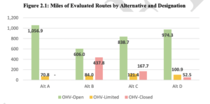
The link shows you in red the trails that would be closed with that Alternative were selected.

Alternative A represents the no action or current management alternative and consists of the route designations and management objectives made in the 2008 Travel Plan and subsequent route designation revisions. Alternative A reflects the total network of evaluated routes considered for designation in this travel planning effort and is used as a baseline for comparison between the alternatives. In Alternative A, route designations for the TMA would remain unchanged—that is, all 1,127.7 miles of evaluated routes would remain available for OHV use. Of these, 1,056.9 miles would remain OHV-Open, 65.3 miles would remain limited by vehicle width, and 5.5 miles would remain limited to e-bikes. The miles of routes designated as OHV-Open or OHV-Limited includes 197.3 miles of regularly maintained routes (17% of total evaluated miles) and 930.4 miles of minimally maintained routes (83% of total evaluated miles). While changes are not proposed under Alternative A, it still provides for continuation of current route use and would have route use-related effects comparable to the action alternatives.

Alternative B prioritizes protection of wildlife habitats, natural and cultural resources, ecosystems, and landscapes. OHV use is more constrained under this alternative than under any other alternative. Maps posted on September 16th, 2021, showed routes to be designated in preliminary Alternative B as follows: 682.0 as OHV-Open, 81.0 as OHV-Limited, and 364.0 as OHV-Closed. After the maps were posted, internal and external comments resulted in further adjustment to the proposed network wherein several proposed designations were changed to further constrain OHV use and reduce resource and user conflicts (see Section 4.2.1). In Alternative B, 606.0 miles (54% of the evaluated route miles) would be designated OHVOpen, 84.0 miles (7%) OHV-Limited, and 437.8 miles (39%) would be closed. Of the routes designated as OHV-Limited, 75.6 miles would be limited by vehicle size and 5.5 miles would be limited to e-bikes. The routes designated OHV-Open or OHV-Limited would consist of 194.9 miles of regularly maintained routes and 495.1 miles of minimally maintained routes. All but 2.5 miles of routes that would be closed to OHV use under this alternative are minimally maintained. Of the OHV-Closed routes under this alternative, 52.6 miles would remain available for authorized or administrative use only, 5.0 miles would be reserved for passive non-motorized trail use, and the remaining 380.3 miles would be decommissioned and earmarked for reclamation. This alternative would close some segments that are part of the BLM-recognized Jeep Safari trail system

Alternative C represents a balanced approach to OHV access opportunities and a variety of management actions which resolve issues and management concerns while accommodating the BLM’s multiple use mandates and responsibilities. This alternative has OHV-Open, OHVLimited, and OHV-Closed designations that accommodate natural and cultural resource protections while designating more miles of routes for OHV use than Alternative B. In this alternative, 838.7 miles (74% of the evaluated route miles) would be designated OHV-Open, 121.4 miles (11%) OHV-Limited, and 167.7 (15%) OHV-Closed. Of the OHV-Limited routes, 97.6 miles would be limited by vehicle size, 5.5 miles would be limited to e-bikes, and 18.3 miles would be limited seasonally. The routes designated OHV-Open or OHV-Limited would consist of all 197.3 miles of regularly maintained routes as well as 762.7 miles of minimally maintained routes. All routes that would be closed to OHV use under this alternative are minimally maintained. Of the OHV-Closed routes under this alternative, 23.5 miles would remain available for authorized or administrative use only, 10.1 miles would be reserved for passive non-motorized trail use, and the remaining 134.1 miles would be decommissioned and earmarked for reclamation. Under this alternative, all high-value routes in the BLM-recognized Jeep Safari trail system would remain designated for OHV use. There have already been a number of routes earmarked for closure that are in the current EJS trail system, and it is expected we will find more.

Alternative D is the action alternative that would designate the most miles of evaluated routes as OHV-Open, allowing for the most OHV-based access opportunities of any of the action alternatives, and accommodating a full range of uses while still mitigating travel-related impacts. In this alternative, 974.3 miles (86% of the evaluated route miles) would be designated OHVOpen, 100.9 miles (9%) would be designated OHV-Limited, and 52.5 miles (5%) would be Labyrinth/Gemini Bridges Travel Management Plan Environmental Assessment DOI-BLM-UT-Y010-2020-0097-EA 17 closed. Of the OHV-Limited routes, 93.1 miles would be limited by vehicle size, 5.5 miles would be limited to e-bikes, and 2.4 miles would be limited seasonally. The routes designated OHVOpen or OHV-Limited would consist of all 197.3 miles of regularly maintained routes as well as 877.9 miles of minimally maintained routes. All routes that would be closed to OHV use under this alternative are minimally maintained. Of the 52 miles of OHV-Closed routes under this alternative, 11.2 miles would remain available for authorized or administrative use only, 2.0 miles would be reserved for passive non-motorized trail use, and the remaining 39.4 miles would be decommissioned and earmarked for reclamation. Under this alternative, routes in the BLM recognized Jeep Safari trail system would remain designated for OHV use.

Recommended Alternatives

  • Alternative A-No Changes to existing trail system.
  • Alternative D-52 miles closed, but it seems that the most popular trails will remain open.
  • Alternative C-Closes many connecting routes, and there are still many discrepancies where BLM GIS and pdf data do not agree. Part of the 7 Mile Rim EJS will be closed, as well as connecting routes to Courthouse Rock, Tusher Canyon, and Major Point, and Mineral Canyon trail.
  • Alternative B-Would close over 400 miles of trails, including the most popular trails listed above.


Grand Canyon Tuweep Limit on Visitation– What Happened?

On March 24, 2022, the Grand Canyon National Park Service (NPS) announced that they were beginning “civic engagement” to seek public comments for a proposed 3 year advance reservation system in a press release. The Press Release caught the attention of the St George News, which featured an article about the proposed plan that same day.

On March 30, Utah Public Lands Alliance published an article about the proposed Reservation System, asking our members and interested parties to learn more about the limits on usage, and to ask them to submit comments to the National Park Service. Our Facebook posts alone reached a new record of 38,803, by far surpassing the interest of our viewers on any other subject. Many of our members and guests submitted comments before the April 6 deadline.

The NPS received 333 comments during the short 13 days public comments were open. They classified the comments into six primary topic areas and published their comment responses here. It should be noted that in the first paragraph of their response document, they were still referring to the reservation system as “proposed.”

Mid July, UPLA learned that the National Park Service had implemented the reservation system without any changes as a result of the comments that were submitted, now requiring advance reservations to visit the Tuweep area, including Toroweep, Vulcan’s Throne, Kanab Plateau, and Tuweep.

Some of the highlights about the new reservation system are:

  • Reservations can be made on https://www.recreation.gov/timed-entry/10089462
  • Daily Limits are
    • 2 Slots are available for Commercial Tour Operators
    • 18 Slots are available for Private Vehicles
      • 6 are available from 3 to 120 days in advance of your visit date
      • 12 are available up to 2 days in advance
      • You can only reserve for one vehicle
    • 10 Slots are available for Backcountry permits for camping
  • Cost to make a reservation is $2 per vehicle.
  • The previous limits of only 4 vehicles/11 people remain in place

On further investigation, Blue Ribbon Coalition (BRC) learned that the change was done through a Categorical Exclusion (CE) that was drafted on March 9, and signed by Edward T Keable, Park Superintendent, on March 15, 2022, 2 weeks prior to their announcement of accepting public comments. A Categorical Exclusion is a process that bypasses the need for the legal protections afforded by the National Environmental Policy Act (NEPA). Staff made the decision in a backroom, then attempted to sell the illusion they were open to comments from the public to influence the policy.

We determined that our best course of action for the time being will be to work with the NPS staff on the details of the 3 year study rather than to pursue a legal challenge at this time. At the conclusion of the study period, NPS has stated that any final changes will go through the NEPA process, when we will be fully engaged in the fight.

We will work with our NPS representative on influencing the study parameters, including asking that No Shows be tracked as a part of their stats (We are concerned that people will make reservations and then not show up, depriving someone else the opportunity to visit.)  In addition, we will work on getting periodic update reports, and perhaps work on  shortening the study from the current 3 years.

The NPS advised us that for the first year, people arriving without a reservation will be educated, but allowed to enter the area and not be cited. If you have any difficulties visiting the area, or if you have trouble getting a reservation, please email us at info@utahpla.com with the details.

Finally, even though we did not get the objective we wished on this plan, the importance of taking action by making public comments about topics that are of concern to you is extremely important. Blue Ribbon Coalition is a very important ally in our fight to retain access to our public lands. In the last year alone,  BRC has influenced 180 planning processes in 17 states, you are instrumental in that process with 7,500 comments from members to Land Managers.

Thank you for your support, let’s work together to Fight for Every Inch!


Waddy’s Corral is Ready for Parking

Waddy’s Corral is Ready for Parking

The tractor work is done and the fencing is going up. This huge project has been done on time for another busy summer on Sand Mountain. Desert Roads and Trails (DRATS) did an excellent job managing and fund raising for this project to eliminate the poor parking available near Sand Mountain OHV area. The area developed is over 5 acres and should handle at least 50 trucks and trailers for Side-by-Side unloading and will be the new air down spot for Jeepers.   Located next to the Water Tanks, this area was needed to replace the area between the two tanks for a third tank.

The following agencies and businesses donated funds to make the project a reality:


Hurricane City                    $150,000

State Parks OHV                $100,000

UPLA                                    $50,000

Washington County            $50,000

DRATS                                  $47,000

Utah 4Wheel Drive               $10,000

FMCA Jeep Club                    $5,000

Public Donations                    $4,000

Tri-State UTV                         $2,500

Dixie 4 Wheel Drive               $2,000

Mad Moose Rentals              $1,500

Tread Lightly                          $1,500

Thanks also goes to the many attendies to the Winter 4×4 Jamboree which was responsible for the much of the proceeds donated from returns from the event.. We should all be proud of the tremendous support from the local groups to undertake this large of a project and to the BLM for their continued support of our activities to improve the OHV site.


Help Save OHV Access to the North Rim of the Grand Canyon

Help Save OHV Access to the North Rim of the Grand Canyon

The National Park Service is considering a plan to limit OHV visitors to only 20 vehicles per day, including tour operators. Further, their plan requires visitors to obtain one of the permits via their reservation system, with only 6 spots available 120 days in advance, and the remaining 12 available 2 days before the visit.

You can read more about this on the Blue Ribbon Coalition/Share Trails website here, but I urge you to write your comments directly on the National Park Service website here. 

After you submit your comments, please copy and share them either at the bottom of this page or in our Facebook post so we can share them with Blue Ribbon Coalition.


Vernal BLM – Book Cliffs Travel Management Plan Scoping

The Bureau of Land Management (BLM) invites the public to play an important role in helping the BLM identify where motorized transportation on public lands in eastern Utah will be allowed. Today, the BLM Vernal Field Office announced the beginning of a 30-day scoping period to inform the Book Cliffs Travel Management Plan as well as the dates for online open houses to learn more.

The Travel Management Plan will help the BLM to provide a public motorized transportation network to serve visitors and local communities while protecting natural resources. While the 2008 Vernal Resource Management Plan considered public motorized vehicle uses on a landscape scale, this plan focuses on managing individual routes. It will determine whether routes are open, limited, or closed for public motorized use on a route-by-route basis.

The Book Cliffs travel management area in eastern Utah covers approximately 813,446 acres in Uintah County, 5,518 acres in Grand County, and 1,906 miles of routes.

“We look forward to hearing from the public during the Book Cliffs Travel Management Plan scoping period,” said Vernal Field Manager Roger Bankert. “Information submitted at this stage will help inform the initial draft of the travel management plan and environmental assessment. The most helpful comments are specific in nature and provide new information.”
The BLM will host online open houses on Wednesday, June 23, from 3:30 p.m. to 4:30 p.m. MST, and Thursday, June 24, from 6:00 p.m. to 7:00 p.m. For more information, meeting access, log in details, and/or commenting online, please visit the BLM’s ePlanning website: http://go.usa.gov/xNKuZ. Relevant maps and materials are posted on ePlanning, including a map with the complete route inventory for the Book Cliffs travel management area. Please note, the includes routes being evaluated for potential inclusion in the Book Cliffs TMP. It does not imply that those roads are available for use under travel management decisions in the Vernal Resource Management Plan.

Comments will help the BLM to formulate issues and alternatives included in the travel management plan. Specific information on the use of route, resource impacts from an existing route, and/or new information about the area is especially useful at this stage in the planning process. The Travel Management Plan will address topics related to motorized travel, including recreation, cultural resources, wildlife and fisheries habitat, soils and water quality, and wilderness characteristics.
The BLM requests public input during a 30-day scoping period starting on June 8, 2021 and ending on July 8, 2021. Comments must be submitted on or postmarked by July 8, 2021, through the BLM’s ePlanning website, by email, or by mail. Please reference “Book Cliffs TMP” when submitting comments.

ePlanning: http://go.usa.gov/xNKuZ
Email: BLM_UT_VN_Comments@blm.gov
Mail: 170 South 500 East Vernal, UT 84078

Before including an address, phone number, email address, or other personally identifiable information in any comments, be aware that the entire comment—including personal identifying information—may be made publicly available at any time. Requests to withhold personal identifying information from public review can be submitted, but the BLM cannot guarantee that it will be able to do so.

People that use public lands in this area should review the documents on the ePlanning site, and write personal comments about specific reasons this area is important to you.

If you would like more about how to write relevant comments, please check out this resource. HOW_TO_WRITE_SCOPING_COMMENTS

Here is the scoping map that shows the current road inventory


Moab Travel Management Plan Update

I would like to thank everyone that submitted comments during the scoping period of the Labyrinth Canyon/Gemini Bridges Travel Management Plan (TMP). As of last Friday, there were 8077 comments filed from all over the United States, and I’m sure that number grew substantially over the weekend.

The Bureau of Land Management is required to go through this review of their 2008 TMP as a result of a settlement agreement they entered into with SUWA. Being a Federal Agency, the BLM is required to follow the procedures laid out in the National Environmental Policy Act (NEPA). This process is required to be completed within 6 years from the settlement date, so it will be ongoing until 2023 through the various processes. In addition, there will be 9 other TMPs that are also required to be reviewed during the next few years.

A common question is, can I make a difference? The short answer is Yes. As an example, the San Rafael Desert released the finalized version of the TMP and it resulted in an increase of authorized trails from 300 miles to more than 765 miles.

UPLA will be providing education on how to make the NEPA process work in our favor, but it will require the ongoing participation of our members and subscribers for several years to come. We will try to provide updates as comments periods open, and how to best structure your comments to be effective.

Marcus from CORE did an excellent video last week that talks about the Moab TMP that will give you an understanding of the process.