Turn Your Trail Experience Into a Powerful Voice
— In Minutes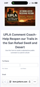
If you’ve ever ridden a trail, camped with your family, or explored Utah’s backcountry, you already have something incredibly valuable: real-world experience.
And right now, that experience matters more than ever.
When the Bureau of Land Management (BLM) considers closing roads and trails, they are required by law to consider substantive public comments—not just opinions, but well-structured, experience-based input.
The problem?
Most people don’t know how to write a “substantive” comment.
That’s exactly why we built the UPLA Comment Coach.
A Tool Built for Real Trail Users
👉 Start here: https://form.jotform.com/261215118081043
Our Comment Coach—powered by Jotform—takes the guesswork out of the process.
Instead of staring at a blank screen wondering what to say, you simply:
- Answer a few guided questions
- Share your trail experience
- Select from structured prompts
- Add your personal observations
That’s it.
From Simple Notes → Substantive Comment
Behind the scenes, the tool organizes your responses into a format that aligns with what the BLM must legally consider.
When you’re done:
- Your comment is automatically formatted correctly
- It is structured to be substantive
- It is emailed directly to you, ready to submit when the comment period opens
No writing skills required. No legal knowledge needed. You ;can edit the text or just copy and paste it to BLM or Forest Service.
What Makes a Comment “Substantive”?
A substantive comment:
- Identifies a specific route or issue
- Explains how and why you use it
- Provides firsthand observations
- Points out potential flaws in agency analysis
- Offers a clear recommendation
That’s exactly what the Comment Coach helps you do—without you having to learn the rules.
Real Example from the Tool
Here’s what a completed comment looks like after using the Comment Coach to answer a few questions:
My name is Loren Campbell. I am a member of Utah Public Lands Alliance, BlueRibbon Coalition and I am submitting comments regarding the reconsideration of route Test346 in Both the San Rafael Swell and Desert. I use this route for UTV/OHV, 4×4, Camping access. I used it once before to camp, and want to be able to go back..
This route is important because it connects to other trails, dispersed Camping or Overlook Trail. This trail connects to several others which is important not only for its scenic value, but also provides connectivity that can be crucial in an emergency on the trail. There is also a fantastic camping site with a great overlook that is no longer available without this route.
From my direct experience, I have observed that responsible use observed
I believe the closure may be flawed and should be reconsidered because Impacts overstated.
I recommend that the BLM Reopen the Route. Please reopen this route, we need it.
I confirm that this is based on my personal experience and thank you for reconsidering this closure.
Respectfully,
Loren Campbell
Virgin, UT
That’s the difference.
Not just a comment—
A comment that must be considered.
Why This Matters Right Now
Across Utah and the West, thousands of miles of routes are being evaluated for closure.
If we don’t speak up effectively, decisions will be made without the benefit of real user experience.
So how much of a difference can it make? In the San Rafael Swell Travel Plan that closed 660 miles of routes, the State of Utah did a detailed analysis of the 5-6000 comments, no routes were closed that had 20 or more substantive public comments. Most roads that had 7 or more substantive comments unless they crossed a known archeological or paleontological site. If there were fewer than 4 substantive comments, the closure rate was high. Generally, the public commented both sparingly and very poorly on short routes that led to overlooks or dispersed campsites, resulting in many closures. Submitting substantive comments can make a huge difference, and if you can get friends that went with you on that ride to also write comments, it can lead to reopening the routes and dispersed camping.
Agencies rely heavily on their own data—but your on-the-ground knowledge is often missing unless you submit it.
Your Voice Carries More Weight Than You Think
You don’t need to be an expert.
You don’t need to write perfectly.
You just need to:
- Share what you’ve seen
- Explain how you use the trail
- Submit your experience in a way that counts
The Comment Coach does the rest.
Take Action in 5 Minutes
👉 Use the UPLA Comment Coach now:
https://form.jotform.com/261215118081043
One Ride. One Form. Real Impact.
Every trail you ride is an opportunity to protect access.
With the UPLA Comment Coach, your experience becomes:
- Organized
- Credible
- Legally relevant
And most importantly—impossible to ignore.
Loren Campbell
President, Utah Public Lands Alliance
 NEW!! Come by our booth and pickup our new Trail Flags to show your Support!