It’s All About the Fight for Moab-Updated Status as of November 2, 2023

By Loren Campbell, President Utah Public Lands Alliance            November 2, 2023


We have been in a fight for access rights for all in Moab for a very long time, and that battle has heated up a lot in the last year as the result of a 2017 Settlement Agreement between the Department of the Interior and Southern Utah Wilderness Alliance to settle a lawsuit from 2008.

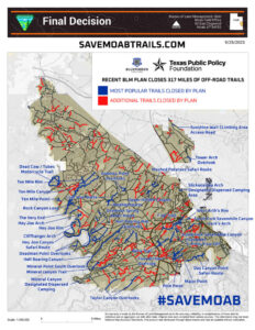
In September, BLM announced their decision to close access to 317 miles of some of the most popular roads and trails in the world in Labyrinth Canyon Gemini Bridges, just north of Moab, 28% of the road network. Also affected by the decision is the closing of almost 120 dispersed camping sites located along the closed roads.

On Monday October 30, an appeal was filed by BlueRibbon Coalition, CO Offroad Trail Defenders. And Patrick McKay. Matt Miller is the senior and lead attorney at the Center for the American Future at the Texas Public Policy Foundation, who filed the appeal with almost 1800 pages of exhibits, hand delivered in boxes to the BLM Moab Field Office.  Mr. Miller said “Every American shares in the ownership of public lands, which exist for the responsible enjoyment of anyone who wants to recreate on them. BLM is trying to move use of these lands from the rights-based system that has endured for decades to a permission based system that allows bureaucrats to close these lands to serve their policy preferences.” To read the full Notice of Appeal, click here.

The State of Utah, the United Four Wheel Drive Association, and a few others also filed appeals.

The Interior Board of Land Appeals has 45 days to respond to the appeal and request for stay, during which time the closures will not go into effect, thus trails will remain OPEN!

Utah Public Lands Alliance has pledged to match the first $50,000 in donations dollar for dollar for BlueRibbon Coalition’s Legal Defense Fund when the donation is made through this link. UPLA is also looking for companies or individuals that will extend the match beyond the first $50,000. In addition, every donor will also be able to claim BRC’s Highly Acclaimed Lost Trails Guidebook Volume 2. Your financial support is essential to winning this fight, please give whatever you can. If your organization would like to learn more about increasing the match, please contact me.

Watch an excellent and comprehensive video by Marcus from CORE that explains where we are and how we get here, including a candid assessment of the BLM decision, the political bias involved at both the local and Federal level, and most importantly why we need to support BlueRibbon Coalition financially. This is a turning point in our fight against the ever increasing federal overreach of their statutory authority, and if we don’t fight to win now, every decision going forward should be expected to have the same consequences.
Visit BlueRibbon Coalition for a map of the most popular trails closed by the Plan and more information. We also encourage you to become a Member of BRC

Access the ArcGIS Map done by Patrick McKay from Colorado Trail Defenders by Clicking here


Our Access to Public Lands is Being Attacked Like Never Before

Our freedom to roam is under assault from a plan to close everything off and make us ask permission before we enjoy it.

There is a plan underway to close the great open spaces of the American West to you, me, our children, and our children’s children. The federal government — which owns most of this land — is determined to move from a “use and let use” system of accessing Western public lands to a permission-based system that will mean reservations, permits, and closures.

Just last month, the Bureau of Land Management issued a final decision to close 317 miles of historic and popular off-road trails near Moab, Utah. For decades, these trails — which are mostly old uranium mining roads — have been enjoyed by everyone from Jeep owners to dirt bike riders to base jumpers looking for a place to land. They have evocative names like Gemini Bridges, Mashed Potatoes, and Dead Cow Trail. They appear in guidebooks. Some of them are even featured in the hugely popular Easter Jeep Safari.

The plan is already being implemented, and it threatens the freedom enjoyed by tens of millions of Americans who hike, camp, Jeep, mountain bike, ATV, fish, swim, canoe, kayak, trail run, overland, base jump, raft, and backpack the millions of acres of free space that make “the West” the West.

I have enjoyed our public lands my entire life. There is nothing like a sip of coffee as you watch the first rays of dawn begin to break on the red rocks. You don’t realize how tough your kids are until they shrug off a chilly 15-degree night in a sleeping bag. And you don’t really appreciate how unfathomably vast the West is until you spend three days exploring the backcountry without seeing another human soul.

All of these experiences — and many others — take place on public lands. There is no entrance fee. There is no permit required. You just lace up your hiking boots, or jump in your pickup, or hop on your mountain bike, and you go. Simple as that. So long you don’t litter or destroy or cause a ruckus, you are left to your own devices. It is something that unites Americans of every class, creed, color, and political persuasion.

That feeling of expansive freedom speaks to everyone who steps outside to enjoy and explore America’s public lands. It feels like our birthright to enjoy them and, for hundreds of years now, it has been just that.

But now, that freedom to roam is under assault from a plan to close everything off and make you ask permission before you enjoy it. If nothing is done to stop it, one of the last, great, unifying forces in American public and private life will be fundamentally transformed and left unrecognizable before most people realize what is happening.

Zooming out, the aggressive rate of federal trail closures is part of the larger “30×30” plan that President Joe Biden announced shortly after taking office. The alleged intention is to “conserve at least 30% of U.S. lands and waters and 30% of U.S. ocean areas by 2030.”

There is no evidence that users of these trails have been damaging them. Indeed, people cherish these lands. Go drive the trails and you will rarely encounter even a single piece of trash. That is why they have been in use for decades with no appreciable degradation.

Nevertheless, the federal government is now implementing a plan to close hundreds of miles of cherished trails. And that is why the BlueRibbon Coalition — the nation’s premier group dedicated to preserving motorized access to wilderness — has joined with the Colorado Offroad Trail Defenders to challenge the plan in court. They are represented by my organization, the Texas Public Policy Foundation.

What the Biden administration’s plan really means is an aggressive plan to close those lands to use by the public. Well, not to the entire public — crunchy backpackers and hikers are still beloved by the left. But the executive decision will limit access for the “wrong” kind of outdoorsy people — people who drive Jeeps and Toyotas and ride ATVs and dirt bikes, and who look like they might be having a good time without suffering under a heavy backpack.

This seems to be a great paradox to those who do not understand why people love overlanding, dispersed camping, dirt biking, ATV riding, and off-roading, but it is no mystery to those of us who actually engage in these activities. We love the wilderness, too. We love taking our children, friends, and family out there and enjoying fresh air and magnificent scenery. If we come across someone else’s trash, we pick it up. If we see someone breaking the rules (by, say, driving off-trail), we reprimand them.

There are very, very few law enforcement personnel on these lands enforcing the rules. Instead, the motorized travel community self-enforces an ethic of respect for public lands. We teach it to our children. That is why these trails remain so attractive as a place to recreate.

The Moab closures are a bellwether case for protecting access to public lands. The closures represent a provocative challenge to an entire way of life for millions of people in the West. If the Biden administration can close these lands, it can close them anywhere. Americans have shown themselves to be responsible stewards of their public lands, and they deserve to be able to enjoy them — freely — for generations to come.

By Matt Miller, Texas Public Policy Foundation     November 2, 2023


How Bad Is the BLM Moab Decision?

Blue Routes Open, Red Closed, All Other Colors Restricted

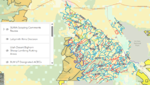
It’s very difficult to comprehend the extent of the adverse actions against OHV access to our public lands. This interactive ArcGIS map of the Labyrinth Rims Gemini Bridges is layered so you can compare the closed routes to lands with wilderness characteristics and bighorn sheep lambing habitat to see that’s where the vast majority of the closures are. There’s also a layer showing SUWA’s Red Rock Wilderness proposal which also includes the areas with the most closures.

This map is the courtesy of Patrick McKay with CO Offroad Trail Defenders Virtual Crew, who has done immense work in trying to protect our access.

Labyrinth Rims Decision (arcgis.com)

If you’re fed up, take action by donating to Utah Public Lands Alliance. Up to the first $50,000, every donation will be matched dollar for dollar and the entire amount given to BlueRibbon Coalition for supercharging our fight. That would big a war chest of $100,000 to get them started!


Help Us Save 199 Miles of Moab Trails

The BLM is expected to release their Moab Labyrinth Canyon Travel Management Plan by September 30, and we are extremely concerned their plan is going to mirror other recent Federal government actions. We’re working closely with BlueRibbon Coalition to help prepare for legal appeals, but We Can’t Do It Without You.

The most common reasons for closure are that a trail is a duplicate, not being used, or is actively being reclaimed. It’s vital to prepare a good legal strategy to know details about every trail, including Trail Conditions, GPX tracks, Photos, and Why the Trail is Important, and we must gather this information BEFORE the closure takes effect.

Thanks to Patrick McKay with Colorado Offroad Trail Defenders, we’ve identified 199 miles of that need a status update.

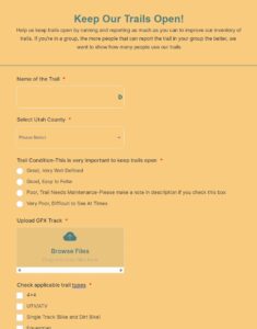
What we need your help with is Running These Trails. Download the free tracks from UtahPLA.com  (We have both GPX and KML versions), load them into your navigation system, and go run the trails. We need you to record your track on the trail and report the Trail Using the UPLA form. Photos tell the story of a thousand words, so if you can submit a few pics that will really help.

Time is limited, so we hope that everyone going to Moab in the next month will help us collect data. Don’t worry about duplicates either, the more reports on the same trail add to our story.

Thank You, and Please Share This Message With All Your Friends

Click Here to Access the Tracks from our CalTopo Site where you can download them in any format you need

Click on From to Open Reporting Form


Running out of time for final Moab comments

Please submit your final comments on your favorite Moab trails to keep them open. The extended Comment period ends Friday.

If you haven’t submitted comments, please do it today.

If you have submitted comments, thank you.

If you want to see more details about exactly which trails are threatened, including maps, guides, and photos, please look at our friend Patrick McKay’s comments here. His comments total 527  pages, and is chock full of information to let you share your personal experiences with trails that will be affected. Please don’t copy and paste his comments, but use it as a reference to help you write your own.

Please submit any final comments by going directly to the BLM website

                                                          Thank you very much!


Time is Running Out to Save Moab Trails!

We only have until Friday at 5:00 to submit final comments regarding saving iconic Moab Trails. I attended the Grand County Commission Hearing last night to make comments protesting their support of Alternative B, which would remove 437 more miles of trails from the network. The Commission approved the recommendation letter (Vote 7:0) to BLM that will remove iconic FMCA Trails 7 Mile Rim, Gemini Bridges, Golden Spike, Gold Bar Rim, Hey Joe Canyon, Mashed Potatoes, and parts of 3D Hidden Canyon. For a more complete list of trails click here. In addition, many spurs off popular routes throughout the area that go to scenic overlooks such as Monitor and Merrimack, the Tusher Tunnel, and many others will closed to motorized traffic forever. For a more complete list of trails to be closed, and the reasons can be found here

You can submit comments 2 ways:

  • If you’d like to use the Blue Ribbon Coalition’s comment writer, click here. It will generate a templated letter, which you can edit and delete your personal details. Personalizing it with your personal experiences and details are what make this method effective. Pictures can tell the story of a thousand words.
  • Click on this link to go directly to the BLM comments page. You can write a free form text on their form, or attach documents in most popular forms such as word, excel, pdf, and jpg photos. You can combine all your comments into one single post, or you can post as many as you want. I recommend you do a single post for each trail you want to report on.

What should you include in your comments? Anything that is of importance to you in retaining access, but here are some thought starters:

  • How long you’ve been using the trail?
  • Do you bring your family?
  • How often you come?
  • How long do you stay in Moab when you visit?
  • Is the trail on your bucket list to do in the future?
  • How much do you spend on each visit?
  • What do you love most about the trail? Challenge, Remoteness, Views
  • Did you observe any educational signs on the trail about responsible use, conservation, etc?
  • How well known is the trail? Is it in specific guidebooks or publications?
  • Is it an important connector between 2 trail networks?
  • Are there dispersed camping sites that you’ve enjoyed, or want to come back to?
  • Do you have any mobility issues that would prevent you from visiting this trail if you could not use a motorized vehicle?
  • Is the trail well marked? Is it in good or obscured condition?

We are not crying wolf, either make your voice heard on this critical issue, or remain silent about the loss of these trails. Write your comments today!