Watch our Youtube Update on the BLM Sand Mountain Land Exchange

Join UPLA and DRATS for an update about the Sand Mountain Land Exchange, and get your questions answered. Loren Campbell from UPLA and Jeff Bieber will be taking your questions via chat during the call.
We are getting great comments being submitted, but like anything of great importance, there are lots of rumors that we want to do our best to answer.
This Zoom event is limited to the first 100 people, but you must preregister. Register Here
If the event fills up, we will either post the recording or reschedule a repeat session.
 Scoping is underway for the proposed Land Exchange for the Washington County Water Conservancy District to obtain 1050 acres of land from the Western portion of Sand Mountain OHV area near Warner Valley. Part of this may be to provide land for the new reservoir, to which we have no objection, but we are in opposition to the addition of the land east of Warner Valley Rim which would affect West Rim and Ridgeline Trails. We are also opposed to the loss of disbursed camping in both Warner Valley and on the Pipeline Road. The camping on Pipeline Road is incomparable for the remote locations and incredible views, and is truly irreplaceable. You can learn more about the latest details at www.UtahPLA.com
What is Scoping? The National Environmental Policy Act (NEPA) requires the Bureau of Land Management (BLM), to involve the public in the planning process and seek their input through a scoping process, which is one of the first steps of the process. It will be followed by BLM’s preparation of a draft Environmental Assessment (EA) , and you will have another opportunity to add substantive comments. Effective NEPA scoping comments for BLM should ask these kind of questions, some thought starters have been included in italics, but come up with your own questions, please don’t just copy this list, put it into your own words.
Scoping is not about stating opinions or venting, it’s about developing the questions that should be answered in the EA or EIS. Framing your comments into questions are the best way to elicit consideration for that question to be addressed in future evaluations. No comment is worthless, but comments that are very broad such as “I don’t want this exchange to happen” are not very helpful if not supported by specifics. If you have detailed and specific comments, I encourage you to submit comments using Option 1 below. If are limited in time and want to make quick comments, I suggest you make your comments using the Blueribbon Action Alert Option 2, it has an excellent set of comments that cover a wide range of subjects. When you submit using the Blueribbon Action Alert, copies will be sent to BLM and Congress. The best option is to submit them both ways.
We have received many excellent copies of comments already submitted, but one from the Capital Trail Vehicle Association from Helena, MT is very well written and may give you more ideas. You can see their comments here….
Now is the time to submit your comments, visit www.UtahPLA.com for the very latest information.
Comment Period Closes at Midnight on April 19, 2023
You can submit comments as often as thoughts arise, but start submitting today!
 Scoping is underway for the proposed Land Exchange for the Washington County Water Conservancy District to obtain 1050 acres of land from the Western portion of Sand Mountain OHV area near Warner Valley. Part of this may be to provide land for the new reservoir, to which we have no objection, but we are in opposition to the addition of the land east of Warner Valley Rim which would affect West Rim and Ridgeline Trails. You can learn more about the latest details at www.UtahPLA.com
What is Scoping? The National Environmental Policy Act (NEPA) requires the Bureau of Land Management (BLM), to involve the public in the planning process and seek their input through a scoping process, which is one of the first steps of the process. It will be followed by BLM’s preparation of a draft Environmental Assessment (EA) , and you will have another opportunity to add substantive comments. Effective NEPA scoping comments for BLM should ask these kind of questions, some thought starters have been included in italics, but come up with your own questions, please don’t just copy this list, put it into your own words.
Scoping is not about stating opinions or venting, it’s about developing the questions that should be answered in the EA or EIS. Framing your comments into questions are the best way to elicit consideration for that question to be addressed in future evaluations. No comment is worthless, but comments that are very broad such as “I don’t want this exchange to happen” are not very helpful if not supported by specifics. If you have detailed and specific comments, I encourage you to submit comments using Option 1 below. If are limited in time and want to make quick comments, I suggest you make your comments using the Blueribbon Action Alert Option 2, it has an excellent set of comments that cover a wide range of subjects. When you submit using the Blueribbon Action Alert, copies will be sent to BLM and Congress. The best option is to submit them both ways.
Now is the time to submit your comments, visit www.UtahPLA.com for the very latest information.
Comment Period Closes at Midnight on April 19, 2023
Start Now, and Get your Comments Submitted!
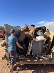
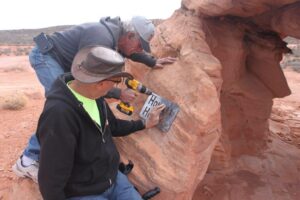
On March 17-18, 2023, volunteers from Utah Public Lands Alliance, Desert Roads and Trails Society, St George Jeepers, and Ride Utah will be meeting at Waddy’s Corral on Sand Mountain to work on several service projects around the area. We are expecting attendance at this event to be unprecedented in scope and size. Combining the resources of 4×4 and UTV/ATV groups working 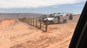 together, along with our partners, the Bureau of Land Management is the way we will win the fight to keep our public lands accessible.
Among the projects we are tackling will be the completion of the staging area fencing, installation of educational street signs and obstacle plaques, cleanup of the Warner Valley and Washington Valley Staging Area, and repairs to the damage to the Competition Hill Composting Toilet.
All Volunteers should report to Waddy’s Corral each day at 9:00 AM for a quick meeting and to split up to tackle one of the projects. Volunteers should bring an assortment of hand tools, shovels, pick axes, trash grabbers, 5 gallon buckets, gloves, water, lunch, and snacks. Pickups or trailers are very helpful on the cleanup projects.
BLM is providing logistical support including dumpsters and trash bags.
We expect to have media present to cover the event, and we encourage all participants to take photos of the effort and to share them on social media with a hashtag of #sandmtnproject2023
For more information, please email us with your questions
Loren Campbell
President
Utah Public Lands Alliance
Together We Will Win,
But We Can’t Do It Without You!
 What is R.S, 2477? RS 2477 is a federal law that authorized construction of roads across federal public lands that was passed in 1866. It helped settle the West for 110 years. Residents of Utah, visitors, pioneers, and settlers created and used thousands of roads across public lands for farming, ranching, hunting, recreating, mining, and connecting communities. We continue to use many of these routes daily and some occasionally or seasonally.
Although Congress repealed R.S, 2477 in 1976 when they enacted the Federal Land Policy and Management Act (FLPMA), Section 701 preserved all R.S. 2477 rights of ways that existed at the time FLPMA was passed and preserved them for public use.
There is no formal administrative or judicial process under FLPMA, but in 2012 the Utah Attorney General filed lawsuits relating to R.S. 2477 rights of wa
y. In 2015, the Utah Federal District Court entered an order that established a process for processing 12,500 right of way claims throughout the state. One of the requirements was that Utah had to submit proof of county maintenance or public use of claimed right of way for a period of at least 10 years prior to October 21, 1976.
It is important to note that R.S. 2477 routes can be across both private and public land, which is especially important to protect access to public land that crosses over privately owned land. This is becoming even more important as development increases throughout Utah.
PLPCO’s Role The Utah Public Lands Policy Coordinating Office (PLPCO) is a state agency that provides research and litigation support for R.S. 2477 claims. One of their first tasks was to document each of the 12,500 Utah roads, which is available publicly on their Access Map 360° , which shows not only the route, but also video tours of the routes to show the condition of their existence.
How to get Help If a route is threatened near you, and you want to see if R.S. 2477 may help in keeping it open, follow these steps.
PLPCO has Attorney Generals in their office that will assist in working the claim, often working with your local County Attorney General to resolve the matter.
Utah Code 72-5-104 also provides protection for Prescriptive Easements for public roads in use for more than 10 years. Iron County recentlly passed an Ordinance that makes it illegal to close “public” roads, notifying land owners to reopen the road or face administrative action from the County. I recently testified at a Washington County Planning Commission hearing where they adopted an Ordinance that requires owners include any R.S. 2477 roads be disclosed in their applications to ensure they remain open. UPLA will be pursuing the Washington County Commissioners adopt a similar Ordinance as that of Iron County.
Be sure to let UPLA know of R.S. 2477 issues or pending legislation in your area.