Only You Can Keep Our Moab Trails Open
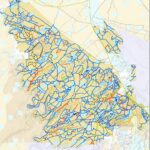 All These Trails In Red Could be Closed Without your Help
The BLM is reviewing their 2008 Travel Management Plan for the Gemini Bridges/Labyrinth area as a result of a 2017 settlement with SUWA. It should be noted as a preface that in the original 2008 TMP, 766 miles of trails were already closed
The proposal for the new TMP affects the holy grail for off roaders, and affects trails northwest of Moab from West of Highway 91 to Green River. This is a huge area, and trails that would be affected by these plans include Hey Joe Canyon, Ten Mile Canyon, Hell Roaring Canyon, Golden Spike, Gold Bar Rim, Rusty Nail, Day Canyon Point, Dead Man Point, Bull Canyon, 3D/Mashed Potatoes Jeep trails, Dead Cow and Tubes motorcycle trails are being proposed for closure. Parts of Where Eagles Dare, Buttes and Towers, Wipe Out Hill, and 7 Mile Rim also will be potentially closed to OHV use.
You must take action to prevent this happening. If you don’t participate, you are giving up not only your voice, but your right to be represented in a legal challenge on your behalf.
How to Take Action
- The best way to take action is to share your personal comments and thoughts about the TMP proposals, and your personal experiences with trails that you have used in the past, or that are on your bucket list that you plan to visit in future. Other things you might mention are
- The popularity of trails and their inclusion in Guidebooks or online resources, or at events such as EJS.
- Physical limitations that would prevent you from enjoying this area other than by motorized vehicles.
- You can do this by submitting your comments here by clicking Participate Now
It has been suggested that multiple comments are more effective than one long list of comments. The BLM form allows 5000 words, but you can also attach many document types directly. If you have photos of your visits, those are also helpful.
Please email your comments to brc@sharetrails.org once submitted.
Please read on to learn about each of the 4 Alternatives, their impact, and at the very end the alternative preferences recommended by Utah Public Lands Alliance and Blue Ribbon Coalition/Share Trails.
BLM has proposed 4 Alternatives that would have the following impact, with a BLM description of that action. 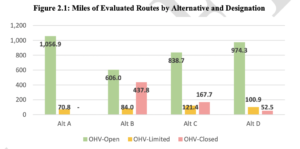 The link shows you in red the trails that would be closed with that Alternative were selected.
Alternative A represents the no action or current management alternative and consists of the route designations and management objectives made in the 2008 Travel Plan and subsequent route designation revisions. Alternative A reflects the total network of evaluated routes considered for designation in this travel planning effort and is used as a baseline for comparison between the alternatives. In Alternative A, route designations for the TMA would remain unchanged—that is, all 1,127.7 miles of evaluated routes would remain available for OHV use. Of these, 1,056.9 miles would remain OHV-Open, 65.3 miles would remain limited by vehicle width, and 5.5 miles would remain limited to e-bikes. The miles of routes designated as OHV-Open or OHV-Limited includes 197.3 miles of regularly maintained routes (17% of total evaluated miles) and 930.4 miles of minimally maintained routes (83% of total evaluated miles). While changes are not proposed under Alternative A, it still provides for continuation of current route use and would have route use-related effects comparable to the action alternatives.
Alternative B prioritizes protection of wildlife habitats, natural and cultural resources, ecosystems, and landscapes. OHV use is more constrained under this alternative than under any other alternative. Maps posted on September 16th, 2021, showed routes to be designated in preliminary Alternative B as follows: 682.0 as OHV-Open, 81.0 as OHV-Limited, and 364.0 as OHV-Closed. After the maps were posted, internal and external comments resulted in further adjustment to the proposed network wherein several proposed designations were changed to further constrain OHV use and reduce resource and user conflicts (see Section 4.2.1). In Alternative B, 606.0 miles (54% of the evaluated route miles) would be designated OHVOpen, 84.0 miles (7%) OHV-Limited, and 437.8 miles (39%) would be closed. Of the routes designated as OHV-Limited, 75.6 miles would be limited by vehicle size and 5.5 miles would be limited to e-bikes. The routes designated OHV-Open or OHV-Limited would consist of 194.9 miles of regularly maintained routes and 495.1 miles of minimally maintained routes. All but 2.5 miles of routes that would be closed to OHV use under this alternative are minimally maintained. Of the OHV-Closed routes under this alternative, 52.6 miles would remain available for authorized or administrative use only, 5.0 miles would be reserved for passive non-motorized trail use, and the remaining 380.3 miles would be decommissioned and earmarked for reclamation. This alternative would close some segments that are part of the BLM-recognized Jeep Safari trail system
Alternative C represents a balanced approach to OHV access opportunities and a variety of management actions which resolve issues and management concerns while accommodating the BLM’s multiple use mandates and responsibilities. This alternative has OHV-Open, OHVLimited, and OHV-Closed designations that accommodate natural and cultural resource protections while designating more miles of routes for OHV use than Alternative B. In this alternative, 838.7 miles (74% of the evaluated route miles) would be designated OHV-Open, 121.4 miles (11%) OHV-Limited, and 167.7 (15%) OHV-Closed. Of the OHV-Limited routes, 97.6 miles would be limited by vehicle size, 5.5 miles would be limited to e-bikes, and 18.3 miles would be limited seasonally. The routes designated OHV-Open or OHV-Limited would consist of all 197.3 miles of regularly maintained routes as well as 762.7 miles of minimally maintained routes. All routes that would be closed to OHV use under this alternative are minimally maintained. Of the OHV-Closed routes under this alternative, 23.5 miles would remain available for authorized or administrative use only, 10.1 miles would be reserved for passive non-motorized trail use, and the remaining 134.1 miles would be decommissioned and earmarked for reclamation. Under this alternative, all high-value routes in the BLM-recognized Jeep Safari trail system would remain designated for OHV use. There have already been a number of routes earmarked for closure that are in the current EJS trail system, and it is expected we will find more.
Alternative D is the action alternative that would designate the most miles of evaluated routes as OHV-Open, allowing for the most OHV-based access opportunities of any of the action alternatives, and accommodating a full range of uses while still mitigating travel-related impacts. In this alternative, 974.3 miles (86% of the evaluated route miles) would be designated OHVOpen, 100.9 miles (9%) would be designated OHV-Limited, and 52.5 miles (5%) would be Labyrinth/Gemini Bridges Travel Management Plan Environmental Assessment DOI-BLM-UT-Y010-2020-0097-EA 17 closed. Of the OHV-Limited routes, 93.1 miles would be limited by vehicle size, 5.5 miles would be limited to e-bikes, and 2.4 miles would be limited seasonally. The routes designated OHVOpen or OHV-Limited would consist of all 197.3 miles of regularly maintained routes as well as 877.9 miles of minimally maintained routes. All routes that would be closed to OHV use under this alternative are minimally maintained. Of the 52 miles of OHV-Closed routes under this alternative, 11.2 miles would remain available for authorized or administrative use only, 2.0 miles would be reserved for passive non-motorized trail use, and the remaining 39.4 miles would be decommissioned and earmarked for reclamation. Under this alternative, routes in the BLM recognized Jeep Safari trail system would remain designated for OHV use.
Recommended Alternatives
- Alternative A-No Changes to existing trail system.
- Alternative D-52 miles closed, but it seems that the most popular trails will remain open.
- Alternative C-Closes many connecting routes, and there are still many discrepancies where BLM GIS and pdf data do not agree. Part of the 7 Mile Rim EJS will be closed, as well as connecting routes to Courthouse Rock, Tusher Canyon, and Major Point, and Mineral Canyon trail.
- Alternative B-Would close over 400 miles of trails, including the most popular trails listed above.
