Bears Ears Resource Management Plan-Comparison of Alternatives

Bears Ears National Monument (BENM) is an exquisitely beautiful and unique 1.36-million-acre gem of public land, located in Southern Utah. BENM is currently going through resource management planning following recent expansion of the monument by presidential proclamation. For more details on the monument expansion, history of BENM, and discussion of resource management planning versus travel management planning for public lands, check out our recent articles on these topics on the Utah Public Lands Alliance (UPLA) website.

The proposed Resource Management Plan (RMP) for BENM was developed via collaboration of the Bureau of Land Management (BLM), US Department of Agriculture’s Forest Service (FS), and the Bears Ears Commission (a group representing six Native American tribes). The RMP includes five Alternatives for public comment. All five Alternatives will result in detrimental impact on outdoor recreation access in BENM. Thus, we urge our members and other outdoor recreation enthusiasts to take advantage of the public comment period to advocate for preservation of recreation access. In this article, we’ll compare the varied levels of impact across the five Alternatives. The deadline to submit public comments is June 11, 2024.

The common thread through all five proposed Alternatives in the BENM RMP is: recreation access is viewed as a threat to preservation of natural and cultural resources. Rather than evaluate how recreation can be managed to prevent and mitigate potential impacts on natural and cultural resources, closed or restricted access is the dominant strategy utilized. Unique characteristics of each alternative include:

  • ALTERNATIVE A: this is the “no action” alternative by which (most) existing management would continue.
    • BLM lands: eight special recreation management areas (SRMAs) and two extensive recreation management areas (ERMAs) would remain intact.
    • Forest Service lands: management based on Recreation Opportunity Spectrum (ROS) categories of primitive, semi-primitive non-motorized, semi-primitive motorized, and roaded natural.
    • Travel management (OHV): existing designated OHV routes would remain open (see table below)
      • 928,080 open to limited OHV access
      • 436,075 acres closed to OHV access
    • Areas of Critical Environmental Concern (ACECs): existing ACECs would remain in place, no new ACECs would be created
    • Recreational shooting: permitted
    • Recreational facilities: existing facilities would remain open and intact
  • ALTERNATIVE B: provides the most permissive management for recreation access considerations. However, conservation is still heavily prioritized over recreation and public access.
    • BLM lands: would be managed through four SRMAs and four ERMAs
    • Forest Service lands: same as Alternative A
    • Travel Management (OHV):
      • 797,525 acres open to limited OHV access
      • 566,627 acres closed to OHV access
    • Travel Management (aircraft): landings and takeoffs would be limited to Bluff Airport and Fry Canyon Airstrip, with the potential for additional locations to be identified in future implementation level decisions.
    • ACECs: BLM would designate the Indian Creek ACEC, Lavender Mesa ACEC, and Valley of the Gods ACEC. The San Juan River ACEC and Shay Canyon ACEC would not be designated as ACECs.
    • Recreational shooting: permitted generally, with the exception of closures in the Indian Creek Corridor Recreation Management Zone (RMZ), San Juan River SRMA, and prohibitions in campgrounds, developed recreation facilities, climbing areas, existing and designated trails, parking areas, trailheads, across roadways, rock ES-7 writing sites, and structural cultural sites. If problems with recreational shooting occur in the future, the BLM would consider future restrictions or closures.
    • Recreational facilities: may be developed as needed
  • ALTERNATIVE C: similar to Alternative B, with additional restrictions to use of drones
    • BLM lands: same as Alt B
    • Forest Service lands: same as Alt A
    • Travel Management (OHV):
      • 700,122 acres open to limited OHV access
      • 664,030 acres closed to OHV access
    • Travel Management (unmanned aircraft / drones): use of drones eliminated throughout most of BENM, with case-by-case exceptions through a permitting process
    • ACECs: same as Alt B
    • Recreational shooting: same as Alt B
    • Recreational facilities: limited development of facilities with emphasis on maintaining natural conditions across the landscape
  • ALTERNATIVE D: severe restrictions to recreation access; the primary management priority is for landscape conservation that is achieved through eliminating or heavily restricting recreation
    • BLM lands: managed through creation of seven Management Areas
    • Forest Service lands: same as Alt A
    • Travel Management (OHV):
      • 381,239 acres open to limited OHV access
      • 982,914 acres closed to OHV access
    • Travel Management (aircraft): same as Alt B
    • Travel Management (unmanned aircraft / drones): same as Alt C
    • ACECs: BLM would designate the Indian Creek ACEC, Lavender Mesa ACEC, Valley of the Gods ACEC, John’s Canyon Paleontological ACEC, and Aquifer Protection ACEC. The San Juan River ACEC and Shay Canyon ACEC would not be designated as ACECs.
    • Recreational shooting: same as Alt B
    • Recreational facilities: minimized development of recreational facilities and management in favor of emphasizing natural conditions
  • ALTERNATIVE E (the preferred alternative): most recreation access eliminated throughout BENM; maximizes the considerations and use of Tribal perspectives on managing the landscape; emphasis is on resource protection and the use of Traditional Indigenous Knowledge and perspectives on the stewardship of the landscape.
    • BLM & Forest Service lands: SRMAs and ERMAs would be eliminated; recreation managed based on a zoned approach. Four zones would be designated: Front Country, Passage, Outback, and Remote.
    • Travel Management (OHV):
      • 794,181 acres open to limited OHV access
      • 569,971 acres closed to OHV access
    • Travel Management (aircraft): same as Alt B
    • Travel Management (unmanned aircraft / drones): same as Alt C
    • ACECs: all existing ACECs would be carried forward, the John’s Canyon Paleontological ACEC and Aquifer Protection ACEC would also be designated.
    • Recreational shooting: eliminated in full throughout all of BENM
    • Recreational facilities: development allowed only in Front Country and Passage zones, when deemed an absolute necessity

As you can see from the management guidelines proposed by each alternative, there is no alternative that is pro-recreation. A pro-recreation alternative would retain all existing recreation opportunities in the monument as open, including all currently designated motorized routes. It is critical to emphasize that management by closure is not management; rather, this method of “management” serves to banish the public from the opportunity to access and enjoy our public lands. There are many effective strategies to manage public lands, including BENM, by means other than road closures, activity bans, group size limits, and exclusion zones.

We encourage outdoor recreation enthusiasts to submit comments on this RMP to advocate for a pro-recreation alternative that would involve active management techniques such as constructing new infrastructure to sustainably handle increased visitation; this would include new trails, trailheads, parking areas, bathroom facilities, campgrounds, etc. It is possible to manage the natural landscape in a manner that conserves the land, protects wildlife habitat, and retains the rugged, wild characteristics of the landscape, while also creating appropriate places, structure, and guidelines for humans to access, enjoy, and recreate throughout the land.

For more details about the BENM RMP, along with guidance on how to write a high-impact comment to submit for the public comment period, join us for a webinar on May 30 at 6:30pm MT. Utah Public Lands Alliance and BlueRibbon Coalition are partnering to share about how the RMP will affect OHV and outdoor recreation access. Tips and best practices will be presented to help you craft your own substantive comment. Click this link to register for the webinar.

For more details about the Bears Ears National Monument RMP, check out the RMP planning website, the draft RMP, and the BLM’s press release and invitation for public comment:

UPLA is continuing to review the draft RMP and seek guidance from the outdoor recreation community to identify areas of concern regarding the impacts of each proposed Alternative  If you have questions or would like to share your input on the draft RMP, please contact UPLA’s Natural Resources Consultant, Rose Winn, at rose@uplapla.com.


Bears Ears RMP Plan Analysis-Article 1

This article is 2 pages, please scroll to second page for more. This is the first article in a series about how to take action to stop them. Watch for more to come on specific tips. We will also be scheduling a Webinar soon.

Winn Rose – Bears Ears Article Series 1


Resource Management Plans vs Travel Management Plans

Many of our treasured public lands in the state of Utah are going a variety of management planning revisions at this time or will be soon within the coming year. Current, active plans include the Bears Ears National Monument Resource Management Plan and the San Rafael Swell Travel Management Plan. For an overview of current and upcoming active plans, check out this article that provides an overview of those that are slated within the next several months.

The American people collectively own all public lands. They are one of the most valuable endowments of our citizenship, wherein every American may enjoy the rich beauty and vast array of natural and cultural resources that our public lands embody. Through the direction of the US Congress, various federal and state agencies like the Bureau of Land Management (BLM) and US Forest Service are designated to manage our public lands for the benefit of the American people. Agencies like the BLM and Forest Service do not own our public lands, they are merely responsible to manage it. Thus, as citizens, it is our right and responsibility to help direct each agency in public land management by participating in the planning process. Anyone who enjoys recreation or use of public lands for activities like off-roading, camping, horseback riding, hiking, mining, etc., must provide their input during the planning process to ensure that access to public lands for such purposes is prioritized and protected as management decisions are made.

In order for us to be effective as we participate in public land management planning, it is important to understand the goals and purpose of different types of plans. For example, right now we have the opportunity to provide public comment on a Resource Management Plan (for Bears Ears National Monument), and we’ll soon have the same opportunity to comment on a Travel Management Plan (for San Rafael Swell). What is the difference between a Resource Management Plan (RMP) versus a Travel Management Plan (TMP). RMPs and TMPs serve different but complementary purposes.

A Resource Management Plan is a comprehensive document that outlines the long-term management goals and strategies for a specific area of public land, such as a national forest, park, or wildlife refuge. RMPs typically address a wide range of natural and cultural resources, including wildlife habitats, water quality, vegetation, archaeological sites, scenic values, and recreational opportunities. These plans are often developed through a collaborative process involving stakeholders, agencies, and the public to ensure that multiple interests and perspectives are considered. RMPs provide guidance for land managers in making decisions about resource use, conservation, development, and restoration within the designated area. RMPs are intended to function like a 30,000-foot overview; they solely address management structure at a programmatic level, creating guidelines and guardrails for future site-specific and trail-specific plans. Per directives from Congress (36 CFR 212), RMPs do not make site-specific decisions regarding travel management because travel management decisions are made at the project level.

A Travel Management Plan focuses specifically on the management of motorized and non-motorized travel within a given area of public land. TMPs are developed to address issues related to off-road vehicle use, hiking, biking, horseback riding, and other forms of recreational travel. These plans aim to balance the public’s interests for recreational access with the need to protect natural and cultural resources, minimize conflicts among user groups, and ensure public safety. TMPs often involve the designation of specific routes, trails, and areas for different types of travel, as well as the implementation of regulations and enforcement measures to manage recreational use responsibly.

While RMPs focus on the broader management of natural and cultural resources, TMPs specifically address the management of recreational travel activities within a designated area of public land. Both types of plans are important tools for protecting public access to public lands, while ensuring the sustainable and responsible management of our treasured public lands for current and future generations. While it is of critical importance for outdoor recreation enthusiasts to participate in the planning process, it is equally important that we understand the goals and purposes of each plan to ensure that our public comments are effective, that the BLM, Forest Service, or other management agency actually uses our comments to shape the final decision for each plan. Increasingly, it is also critical that we hold managing agencies accountable to ensure that site-specific and trail-specific decisions are addressed solely within TMPs, and not implemented within RMPs.

Over the last several years, a disturbing trend in public land management planning is that public access and recreational uses take a backseat in priority in the planning process; an extreme environmentalist agenda is elevated in many public land management decisions. One example of this is the recent TMP that was implemented for the Labyrinth Rim & Gemini Bridges area near Moab. This is just one example, there are many more. Thus, our mission at UPLA is to inform and equip you to join in the effort to preserve public access to public lands for all forms of outdoor recreation. We offer resources and support to make it easy for you to participate in public land management planning, and to stay up-to-date on current plans that are open for public comment. We invite you to join us in the effort to protect public access to our nation’s beautiful public lands!

Rose Winn
Utah Public Lands Alliance
Natural Resource Consultant
Rose@UtahPLA.com


Upcoming Utah BLM Travel Management Plans

February 20, 2024 Update-I met with Matt Preston, Deputy Utah State Director for BLM to discuss upcoming Travel Management Planning (TMP) for Utah. We went over each of the following 5 areas that I spoke to Dave Jacobson about, and some general considerations in the planning process. Matt indicated that the primary objective for BLM planning is resource management, and that comes from the very top of our government. While recreation will remain an important factor in decisions, increasing weight is being placed on decisions for ways to protect and/or mitigate effects on the environment. Matt has already setup contacts for me with the next 2 Travel Management Area (TMA) project managers, and I will be getting more information from them within the coming days.

He also explained that for the SUWA Settlement TMPs, there is an extra step in the process where they will release Preliminary Alternatives before the Draft EA. This will include a map of the tentative routes for each alternative. This will give us an important tool to begin the process of doing detailed evaluation of all the routes. The Preliminary Alternatives for the San Rafael Swell were released today. You can view the four alternatives by clicking here. We will ask for better maps on our calls in the coming days. There are over 2,000 miles of routes in the Swell, and a lot of lots slated for closure in Alternatives B and C. This will require a lot of concerted effort to begin the process of surveying the trails and preparing comments. This will be the test bed of our process to accomplish this.

The general descriptions for the various alternatives can be described as the following:

  • A=No Changes to Current Plan
  • B=Conservation focused, largest OHV closures or restrictions
  • C=Balanced alternative between OHV and Conservation
  • D=OHV Focused Alternative, little closures and perhaps some additions

The Preliminary Alternatives will proceed the release of the Draft EA, so we will have more time to prepare our research.

I asked him about the general direction of BLM in their Alternative decision, and he said that we should expect to see less reliance on BLM selecting an Alternative, but rather a route by route analysis and decision on each route individually. This will require us to take a much wider focus on routes, including an additional focus on B alternative routes. You should stay tuned on some new tools UPLA is working on to assist us in this process.

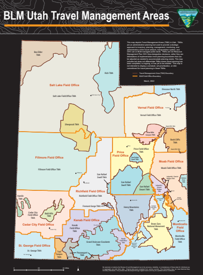
I met with Dave Jacobson on February 5, the newly appointed Travel Management Plan Manager for Utah. I wanted to get an updated listing of all of the TMPs and RMPs coming down the pike so we can get ahead of them. There are 24 TMPs in Utah, and one more RMP to come in the Grand Staircase. Here’s the map that shows each area.Utah TMP and Field Office Map

Here’s the breakdown of Plans around the corner.

  1. Priority List of TMPs coming and expected next date for comments and estimated final date
    1. San Rafael Swell (Price)-Comments should reopen around March 1, with Final by November 2024
    2. Bears Ears (Monticello)-Comments should open February 2024, Final by end of 2024
    3. Henry Mountains & Freemont Gorge (Richfield)-Comments should open around May 2024, with Final by November 2024
    4. Trail Canyon (Kanab)-Comments should open in April 2024 with Final end of 2024
    5. Delores River (Moab)-Very small, it will go fast, expect final January 2025

Start running trails on this Priority List, record the tracks, take photos, and put together your stories about what the trail means to you. We will address each TMP separately as we get information.

One other request that Dave thought would be very helpful is to volunteer to your local BLM office to take them out on a field trip so they can see the land, how we use it, and how we take care of it. It is suggested you contact your local District Field Manager or you can email Dave Jacobson and he will arrange some staff to join you. This will be a great way to get to know your local managers.


Bears Ears National Monument Poses Devastating Loss to OHV

How to Protect OHV in Bears Ears National Monument

The Bears Ears National Monument (BENM) was restored in size by President Joe Biden to 1,360,000 acres, making it one of the largest in the country. As a result, a new management plan is being developed that will decide how the land will be managed (used). The Scoping Document BLM prepared will be one of the largest eliminations of OHV use I’ve ever seen. Some of the most popular OHV routes would be Arch Canyon, Hotel Rock, Lockhart Basin, Beef Basin, Bridger Jack Mesa, Lavender Canyon, and Davis Canyon, with many, many more subject to the axe.

And it won’t just affect OHV use, if you are a hiker, dispersed camper, miner, drone pilot, or equestrian user that depends on access roads to get to your favorite sites, you will also be extremely limited on your use of the BENM under the current proposals.

BENM is a huge area with very diverse uses and landscapes,and is surrounded by other currently protected areas including National Parks, Wilderness, Wilderness Study Areas, and even another National Monument already contained in its massive boundaries. BLM’s scoping document should make the alternatives easier to understand, but this one makes it even more complex. NEPA requires that BLM and USFS consider a reasonable range of alternatives in their plans. OHV use is already limited in the entire BENM, meaning that you may only operate on designated routes. In addition, OHV use is already prohibited in Designated Wilderness (DW), Wilderness Study Areas (WSA), and Inventoried Roadless Areas (IRA),

Alternative A is the No Change required alternative. It is generally provided as a requirement to the “full range of options” legal requirement. It is always included as an obligatory placeholder,and is almost never selected in the final draft. Target shooting and drone operation would be permitted with some restrictions under this Alternative.

Lands with Wilderness Characteristics

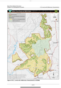
Alternative B adds Lands with Wilderness Characteristics to closure by OHV, as evidenced by the following chart which indicates how much of BENM will be closed to OHV. The BLM website states that for an area to qualify as lands with wilderness characteristics, it must possess sufficient size, naturalness, and outstanding opportunities for either solitude or primitive and unconfined recreation. It may also possess supplemental values.

The addition of “lands with wilderness characteristics” is an enormous tract of land depicted in the green hashed marks that will affect much of the 1800 miles of OHV routes, as well as many connecting routes between areas that will be cutoff from motorized vehicles. In addition, other special use restrictions such as limits on group sizes and permits will be required.  In addition, target shooting and drone would be prohibited throughout the entire BENM.

Alternative C will probably be considered as the “balanced” approach, but it is definitely not for OHV and many other forms of recreation. It would divide the BENM into many different Recreation Opportunity Spectrum (ROS) zones, which all will have different limits and regulations  on use. The language regarding this is not only vague, but contradictory in nature. It also includes “lands with wilderness characteristics” as being Closed to OHV. The language regarding road density and sitage is extremely vague, but their intent seems clear.This Alternative would allow  some limited drone use and target shooting could be done in the “front country” or in designated ROS zones.

Alternative D is Orwellian in scope, adding to the “lands with wilderness characteristics” 3 additional restrictions with no formal definitions.

  • 1) Areas where OHV use has damaged or is a current or foreseeable future risk to the protection, restoration, and resiliency of BENM objects and values. If the authors of this proposal are the unelected bureaucrats deciding this, we are in trouble.
  • 2) Areas where OHV use affects traditional use and cultural setting
  • 3)With the exception of existing designated routes, areas within 300 feet of riparian habitat, perennial springs, and other perennial aquatic ecosystems

Another statement in Alternative D is that “in OHV limited areas, road density would be minimized, and siting criteria would be identified, especially in important resource areas, to ensure the protection, restoration, and/or increased resiliency of BENM objects and values. Future implementation-level travel planning would not allow designation of additional routes but would focus on refining (as needed) the existing designated route network.” Target shooting and drone usage would be prohibited throughout the BENM. In Alternative D, your visit to Bears Ears may very well be limited to driving through in your passenger car with no dispersed camping opportunities, and complex rules that will almost ensure users will be in violation of one of them.

Current Trails Overlaid with Proposed Zones

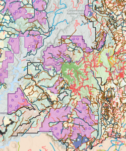
This map shows the complex network of designated areas, along with trails and roads overlaid onto it,


clicking here will display the map in greater detail. . Virtually all of the color shaded areas on this map will be restricted from OHV use.

There is no good alternative from this range of choices, so the best approach at this point is just to tell them you protest the array of current Alternatives, to complain about the lack of clarity on their entire RMP, and to comment on how you have used the area in the past, or plan to use it in the future. Some of the things you might mention are:

  • How long and how often you’ve been coming here
  • Who you have brought to visit the area
  • Activities you’ve engaged in, OHV, Dispersed camping, hiking, equestrian
  • The nature of any conservation efforts you have engaged in, whether it is in BENM or other public lands
  • Specific trails that you enjoy, or plan to enjoy. Specific trails identified now are Arch Canyon, Hotel Rock, Lavender and Davis Canyons, Chicken Corners, Lockhart and Beef Basin, and the Peavine Corridor.
  • If you have mobility or disability issues that limit your visitation


Comments are only being accepted until October 31, so please Visit Blue Ribbon Coalition’s website and complete their comment writer.
if you want to send personal comments about trails you use, submit them on the BLM E-Planning website.