UPLA is focused on three strategies to keep and recapture our loss of access to our public lands, especially for motorized OHV. One powerful option for us is working through the court system. In order to understand this, it’s helpful to have a good understanding of how our judiciary is setup.
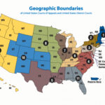
Article III of the US Constitution established the Judicial Power of the United States in one Supreme Court, and Inferior courts as Congress may ordain and establish. Thus cases will begin in a Federal District Court, where the facts of the case are presented and a decision is rendered by applying the Facts of the Case with the Law. In cases of high importance and dispute, appeals can be filed with the 10th Circuit Court of Appeals where a panel of judges will hear and decide the matter.
 There are 13 Federal Circuit Courts of Appeal, and sometimes different Circuits consider similar facts yet result in different decisions. This is often the path that causes a case to be eligible for submission to the US Supreme Court. Getting a case through District and Appeals Courts is a lengthy, complex and expensive process, which cause us to make important decisions on choosing the cases that will have the greatest impact and also with the highest potential for success through the entire process.
Having the Supreme Court hear a case is immensely tougher, the Supreme Court receives around 7000 requests for review each year, and typically only hears about 70, but it is the only way disputes determine what the “law of the land” is in all 50 states.
Here’s the ways disputes get to the Supreme Court:
- Death Penalty cases– All death penalty decisions are automatically reviewed by the US Supreme Court
- Petition for Writ of Certiorari-When a party is dissatisfied with the decision of a U.S. Court of Appeals or the highest court in a given state, they can apply to the Supreme Court. These cases typically involve conflicts in law, very Important and unusual cases, cases where different circuits have rendered conflicting decisions, or cases where a lower court disregards past precedents or involve questions of Constitutionality. The Supreme Court has complete discretion in choosing which cases they will hear. Once a petition (application) is received by the Court, the Court will review it and vote on whether to hear it. Certification of the writ (agreeing to hear the case) requires 4 of the 9 Justices to vote in favor of hearing the case.
- Disputes of Original Jurisdiction-The Supreme Court can hear a case as the original court in a few limited exceptions, generally involving disputes between the states, disputes between a state and foreign powers, or cases where a state is the Petitioner.
Parties interested in expressing their legal opinions on a pending action before the Supreme Court are allowed to file “amicus briefs” on behalf of their organizations/clients. These briefs can be filed both during the application (certification) process and during the preparation for oral arguments phase.
Prior to hearing oral arguments, the Justices get fully prepared in the history of the case. They obtain all the court documents and exhibits, and then each Justice, along with their law clerks review that material along with all the briefs before oral arguments are made. Oral arguments give the attorneys the opportunity to briefly summarize their case, but more importantly it gives them the opportunity to ask questions. After oral arguments are done, the Justices will meet in private conference just a few days later to discuss and vote on the case. The majority vote from that conference becomes the decision, and they begin preparation of their written decision, as well as any dissenting opinions. Although the decisions are made within days of oral arguments, most of the decisions are not released until May or June. Once that decision is released, it sets precedent for all other courts in the country.
The Supreme Court is currently made up of 6 justices that were appointed by Republican presidents and considered to be conservative leaning. 3 of the justices appointed by Democrat presidents and considered to be liberal leaning. With the Court’s current majority of conservative justices, the chances for land use disputes and stricter interpretation of the Federal government’s authority is more favorable for not only BlueRibbon and UPLA, but also the State of Utah.
Here are some important cases that have recently been decided or pending before the Supreme Court
- West Virginia v EPA 2022- Introduced the Major Questions Doctrine that bars agencies from resolving questions of economic and political significance without clear statutory authorization. This decision specifically limited the EPAs authority unless they could prove the underlying statutory authority from Congress. This will place a limit on all administrative agencies.
- Loper Bright Enterprises v. Raimondo 2024-Eliminated Chevron Deference Doctrine. The Chevon Deference came from a 1984 Supreme Court decision which required that lower courts give deference to administrative agencies as being the experts when a statutes were silent or ambiguous. It will require that Congress specifically define the authority an agency has, without that authority, they will be denied. Many suits never were actually heard by the Court due to application of Chevon. As a footnote, lead counsel for this case was Paul Clement, the same attorney in the below Utah v. United States case.
- Corner Post v, Board of Governors of the Federal Reserve System 2024-Most claims for lawsuits often are limited by a statute of limitations, or time period that the suit must be filed. Prior to this case, the time period began when the law or rule was published. In this landmark decision, the Supreme Court ruled that the Statute period begins when the plaintiff is injured. This clear definition will enable matters previously barred by the statute of limitations to be heard in the courts.
- Seven County v Eagle County -To be heard during 2024-2025 session- Uinta County desired to construct a railroad line to connect the isolated Uinta basin with the national rail network. The proposal went through NEPA analysis and was approved in 2021. Eagle County, Colorado, and the Center for Biological Diversity challenged the Board’s decision in the U.S. Court of Appeals for the D.C. Circuit, claiming the Board’s required NEPA analysis was deficient. The challengers insisted that the Board should have considered the new rail line’s potential effects on increased oil drilling in Utah and Colorado, as well as oil refining activities more than 1,000 miles away along the Gulf Coast.construction. The Supreme Court now has a chance to clarify the scope of NEPA review. The decision may have significant implications for a host of important agencies and the many industries that work with them.
- Utah v. United States– This case is pending Certification before the Court. It would answer the question whether BLM has the authority to hold unappropriated public lands indefinitely. Article I, Section 8 of the Constitution specifically limits the powers of Congress, and holding land indefinitely falls outside these authorities. Utah is especially impacted because 70% (37.4 million acres) of Utah land is owned by the Federal government. Lands that have been appropriated such as for National Parks, Wilderness Areas, or National Monuments, or National Forests will not be affected. The suit will require the United States to transfer ownership of approximately 18.5 million acres. Lead Counsel for Utah is Paul Clement, one of the most respected and winningest attorneys practicing before the Supreme Court. Amicus Briefs are currently being accepted for this case.
Blueribbon Coalition is currently litigating important cases throughout the country, and UPLA believes that BlueRibbon is positioned the best to litigate these cases and others. Even though some of these cases may not directly affect Utah, wins elsewhere can be cited, so wins anywhere are important to our cause.
What is UPLA doing to support litigation?
- UPLA has principally aligned itself with BlueRibbon Coalition to litigate cases that will protect our rights for all users to access public lands. BlueRibbon has a paid professional staff to oversee and manage these efforts and also has retained the very best legal counsel
- UPLA will raise funds that will support litigation efforts, and make donations to the best efforts at protecting these rights.
- UPLA created a matching campaign in 2023 that resulted in a total donation of $112,000 to BlueRibbon Coalition for their legal defense fund.
- Because we are a volunteer driven organization without paid staff, UPLA has elected to support selected organizations in their litigation rather than acting on our own, but we may engage in other ways such as submitting Amicus Briefs.
- UPLA is available to speak at your organization or club’s meetings either in person or via Zoom. Contact us to schedule an update
How UPLA needs your help to support litigation efforts
- Join both UPLA and BlueRibbon Coalition-With every comment, call, or letter, mention your membership; this provides us with the ability to represent you in future legal actions
- Subscribe and read our newsletters and social media posts to stay informed
- Contribute as generously as you can when we ask for donations.
- Spread the word about pending cases and our fundraising efforts.
Litigation is one aspect of our strategy to protect your rights to access your public lands in the manner you choose, as long as you do so responsibly. Stay tuned to learn more about other strategies we are employing.


