Help Reopen 400 Miles of Routes in Dino North TMP

Dino North Travel Management Plan: A Different Kind of Travel Plan

For years, Utah Public Lands Alliance has argued that Travel Management Plans should not become exercises in simply reducing motorized access. If routes exist on the ground, serve a public purpose, and can be managed responsibly, they deserve an honest evaluation—not automatic closure.

The Draft Dinosaur North Travel Management Plan is different.

Unlike many recent travel plans that focused primarily on reducing access, the Dinosaur North proposal evaluates an existing transportation network that is far larger than the routes designated in the 2008 Vernal Resource Management Plan.

Our analysis of the Draft Environmental Assessment shows that the current inventoried route network contains approximately 700 miles of existing routes, yet only 279 miles were formally designated in the 2008 Travel Management Plan. That means roughly 421 miles—about 60 percent of today’s inventoried network—were never officially designated for motorized use in 2008. The Draft EA explains that those undesignated routes are treated as closed under Alternative A because they were never formally evaluated or designated. That makes Dinosaur North fundamentally different from most recent Travel Management Plans.

More Than a Closure Analysis

In recent years, much of UPLA’s work has focused on defending existing access against unnecessary closures. That work remains critically important.

Alternative B would still close many existing routes that riders, hunters, campers, photographers, rockhounds, and other public land users value. If you use those routes, your comments remain essential.

However, Dinosaur North also presents something we have long encouraged the Bureau of Land Management to do. It is one of the first major examples where the BLM is proposing to formally designate existing inventoried routes that were not included in the 2008 travel network, almost 400 miles. Rather than simply deciding which routes to eliminate, the agency has evaluated hundreds of miles of existing routes that have long existed on the landscape but were never officially designated. Alternatives C and D would incorporate many of those routes into the official designated transportation system.

That represents the kind of comprehensive route evaluation UPLA has advocated for years.

Your Comments Can Make a Difference

Most people naturally focus on routes proposed for closure. You absolutely should.

If Alternative B proposes closing a trail that provides meaningful recreation, access to hunting areas, campsites, overlooks, historic sites, or connects other important routes, tell the BLM exactly why that route should remain open.

But don’t stop there.

The 400 miles of newly proposed designations deserve your support as well. If a route appears on UPLA’s Newly Designated Routes worksheet and you believe it should become part of the permanent designated transportation system, tell the BLM why that designation is important.

Use TrailSaver.com to format your comments to describe how you use the route, what destinations it provides access to, why it contributes to a connected and sustainable trail system or why formally designating the route improves responsible public access.

Positive comments supporting appropriate route designations are just as valuable as comments opposing unnecessary closures.

Make Your Comments Substantive

Simply saying “keep this trail open” or “I oppose closures” carries very little weight during the NEPA process.

To influence the decision, your comments should be substantive. That’s exactly why UPLA developed TrailSaver.com.

TrailSaver walks you through a series of simple questions about the specific route you use. Based on your answers, it generates a detailed, route-specific comment that addresses the kinds of information land managers are required to consider during the decision-making process. The better your answers and more details you provide, the stronger your comment becomes.

Whether you’re commenting on a route proposed for closure or supporting one of the newly designated routes, TrailSaver helps you create comments that are far more likely to be considered substantive rather than general expressions of support or opposition.

A Better Conversation About Public Lands

Travel management should never be viewed as a choice between opening everything and closing everything.

Good travel planning identifies the routes that provide meaningful public access, protects sensitive resources where necessary, and creates a transportation system that is both sustainable and usable for future generations.

The Dinosaur North Draft TMP provides an opportunity to accomplish exactly that.

Where the BLM proposes unnecessary closures, UPLA will continue advocating to keep valuable routes open.

Where the BLM proposes to formally designate long-existing inventoried routes that were never included in the 2008 travel network, we believe those proposals deserve careful public support when they improve responsible public access.

Both deserve your attention.

UPLA’s Expanded TMP Analysis

To help the public better understand this planning effort, UPLA has expanded its TMP Analysis System to identify not only proposed closures, but also Newly Designated Routes—existing routes that were not designated in the 2008 Travel Management Plan but would become officially designated under Alternatives B, C, or D.

We encourage everyone reviewing the Dinosaur North Draft TMP to look beyond the closure statistics. Study the routes proposed for closure. Study the routes proposed for new designation.

Then use TrailSaver.com to prepare detailed, substantive comments supporting the routes that matter to you.

We are finally beginning to win this battle, but we need your support and engagement to bring it over the finish line.

Thank you for all your Support!

Loren Campbell
President



Trail Canyon Travel Plan Analysis

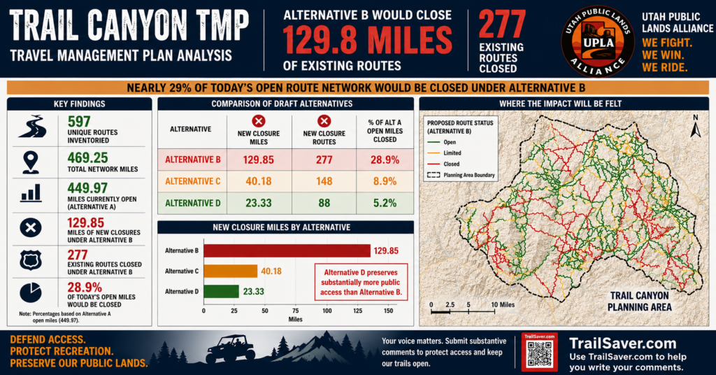
Trail Canyon TMP (Kanab) – Comments opened June 22 and are open till July 22, 2026. The Trail Canyon Travel Management Area (TMA) is located in Kane County, Utah. It is bounded by the Dixie National Forest on the north, U.S. Hwy 89 on the east, the Utah-Arizona border on the south, and Zion National Park on the west. There are 129 miles of routes proposed for new closures in Alternative B out of 450 miles of routes currently open, that’s 29% unless we take action. BLM is having trouble with their Interactive Map, and I want to start examining the trails in detail, so I created GPX files you can upload into OnX or Gaia you can get at the link below.

UPLA created an analysis tool to give a high level overview of the various travel management plan alternatives. In the analysis, you’ll find a complete list of all the routes sorted by Route number (with common names where we have them), another tab shows the Alternative B closures, and then a Top Priority page that shows the largest impacts based on mileage. It should be noted that there are many other factors that may be more important such as connectivity to other routes and other important features on the route.
You can download the complete report here or just tap on the following summary


Trail Canyon and Dino North Travel Management Areas Are Now Open for Comments till July 22


A Turning Point for the Antiquities Act and National Monuments

A Turning Point for the Antiquities Act: The Courts Reclaim Their Constitutional Role

For years, Utah Public Lands Alliance (UPLA) has advocated a simple principle:

Public lands should be managed according to the laws enacted by Congress—not according to assumptions that presidential authority under the Antiquities Act is effectively unlimited.

That principle recently received significant support from the U.S. Court of Appeals for the Tenth Circuit. While much of the public attention has focused on whether the case involved Bears Ears or Grand Staircase-Escalante National Monuments, the court’s decision reaches far beyond those two monuments.

At its core, this case asks a fundamental constitutional question:

When Congress places limits on presidential authority, who decides whether those limits have been followed?

The Tenth Circuit’s answer is straightforward:

The federal courts do.

The Antiquities Act Grants Power—But Also Imposes Limits

When Congress enacted the Antiquities Act in 1906, it gave Presidents important authority to protect historic, prehistoric, and scientific resources on federal lands.

President Theodore Roosevelt quickly demonstrated how valuable that authority could be, proclaiming monuments ranging from Devils Tower and Montezuma Castle to the Grand Canyon. But Congress did not grant unlimited authority.

The statute contains two important limitations that have always been part of the law.

  • First, Presidents may designate only “historic landmarks, historic and prehistoric structures, and other objects of historic or scientific interest.”
  • Second, the land reserved for those objects must be confined to “the smallest area compatible with the proper care and management of the objects to be protected.”

Those limitations were not accidental. Congress deliberately included them to define the scope of the President’s delegated authority.

If Congress Wrote Limits Into the Law, Someone Must Interpret Them

This is where the recent litigation became so important.

The plaintiffs—including the State of Utah, Garfield County, Kane County, BlueRibbon Coalition, and others—argued that the Bears Ears and Grand Staircase-Escalante expansions exceeded those statutory limitations. They did not argue that Presidents lack authority to proclaim national monuments. Instead, they argued that Congress had established legal boundaries governing how that authority may be exercised.

The district court dismissed the case before reaching those questions. In doing so, it concluded that the President’s determinations under the Antiquities Act were largely committed to presidential discretion and therefore not subject to meaningful judicial review.

In practical terms, the district court did not undertake the statutory interpretation necessary to determine whether the identified resources qualified under the Act or whether the acreage reserved satisfied Congress’s “smallest area compatible” requirement.

The Tenth Circuit concluded that approach was incorrect.

The Tenth Circuit Restored the Judiciary’s Constitutional Role

The Court of Appeals did not rule that the monument expansions violated the Antiquities Act. It also did not reduce monument boundaries.

Instead, it held that the district court had an obligation to interpret the statutory limits written by Congress rather than simply defer to the President’s judgment.

  • Congress writes the law.
  • The President executes the law.
  • The courts interpret what the law means and determine whether executive action remains within the authority Congress delegated.

The Tenth Circuit recognized that interpreting terms such as “objects of historic or scientific interest” and “smallest area compatible” is not merely permissible—it is part of the judiciary’s constitutional responsibility.

The case now returns to the district court to perform that analysis.

Why This Matters Beyond One Lawsuit

The significance of this decision extends well beyond Bears Ears and Grand Staircase. For many years, monument litigation often ended with courts giving extraordinary deference to presidential determinations.

The Tenth Circuit has now clarified that the statutory limits contained in the Antiquities Act are not meaningless words. They are legal standards capable of judicial interpretation and review.

Whether future courts ultimately conclude that a particular monument complies with those standards remains to be decided on a case-by-case basis. But the legal framework has changed.

BlueRibbon Coalition’s Role

Some observers have focused on the dismissal of BlueRibbon Coalition from the appeal. That dismissal resulted from a procedural issue concerning the preservation of standing arguments during the appellate process.

The court did not reject BlueRibbon’s substantive legal arguments concerning the Antiquities Act, nor did it hold that BlueRibbon lacked standing on the merits. Although BlueRibbon Coalition’s appeal was dismissed on procedural grounds, the dismissal was without prejudice. The court did not reject BlueRibbon’s legal arguments concerning the Antiquities Act or hold that it could never pursue similar claims in the future. Instead, the Tenth Circuit corrected the district court by emphasizing that jurisdictional dismissals are not decisions on the merits. More importantly, the fundamental legal questions presented by BlueRibbon, Utah, Garfield County, Kane County, and the other plaintiffs remain before the district court. The extensive briefing submitted throughout this litigation helped frame the statutory questions that now return to the district court under the legal framework established by the Tenth Circuit.

BlueRibbon Coalition plans to continue to be part of this case all the way through final judgment.

A Changing Landscape

This decision also arrives during a period of significant change in federal public lands policy. The Executive Branch has increasingly emphasized multiple-use management, responsible public access, and reconsideration of previous land management decisions.

At the same time, the Department of Justice has advanced the legal position that Presidents possess authority not only to establish national monuments but also to modify or revoke monument designations made by previous administrations.

Whether courts ultimately adopt that interpretation remains uncertain. Nevertheless, these developments illustrate that the broader legal and policy landscape surrounding the Antiquities Act continues to evolve.

What This Means for Responsible Recreation

For the off-highway vehicle community, this decision represents something larger than a dispute over monument boundaries. It reaffirms an important constitutional principle. Public lands should be managed according to the laws enacted by Congress. When Congress grants authority, it may also establish limits.

When questions arise concerning those limits, it is the responsibility of the federal courts—not any President acting alone—to determine whether those limits have been respected.

That principle benefits everyone. It protects historic and scientific resources. It preserves the separation of powers established by the Constitution. And it helps ensure that public land decisions remain accountable to the law rather than resting solely on executive discretion.

Looking Ahead

The district court will now undertake the detailed work it did not previously reach—interpreting the Antiquities Act’s statutory limitations and determining whether the plaintiffs have plausibly alleged that those limitations were exceeded. The final outcome of the case remains to be seen. But one thing has already changed. For perhaps the first time in decades, a federal appellate court has clearly reaffirmed that the Antiquities Act is both a grant of presidential authority and a statute containing meaningful legal limitations.

Those limitations matter.

And the federal courts have reaffirmed that interpreting them is one of the judiciary’s most important constitutional responsibilities.

UPLA celebrates this important win and gratefully recognizes the efforts of the State of Utah, Kane County, Garfield County, and BlueRibbon Coalition in achieving this win for overturning the sweeping RMPs for multiple National Monuments that restrict motorized access.

Loren Campbell
President
Utah Public Lands Alliance


Every Trail Has a Story, You Need to Tell It to Keep It Open

The next few months may be some of the most important for motorized recreation access in Utah in many years. On June 22, three major Travel Management Plans are expected to open for public comment:

  • Trail Canyon (Kanab Area)
  • Dinosaur North (Vernal Area)
  • Dolores River

These will be followed shortly thereafter by two additional planning efforts:

  • Henry Mountains Reconsideration
  • Paunsaugunt (Kanab Area)

Together, these five plans will determine the future of access to hundreds of roads and trails across some of Utah’s most iconic public lands.

A New Opportunity for Access

For decades, travel management planning has largely operated under policies that encouraged agencies to focus on restrictions, closures, and route reductions. Today, there is a new attitude toward public land access coming from the highest levels of government. Recent policy changes have made it clear that access, recreation, multiple use, and public enjoyment of our lands are once again important priorities.

That is good news.

But policy direction alone will not keep roads and trails open. Agency planners still need evidence. They need facts. They need local knowledge. They need documentation showing why specific routes matter to the public and why they should remain available for future generations.

In short, they need ammunition to justify keeping routes open.

That is where all of us come in.

The Most Important Voice Is Yours

Every trail has a story.

Some provide access to dispersed camping areas. Others connect trail systems, provide access for hunters, support local tourism, allow access for elderly or mobility-impaired visitors, or simply provide families an opportunity to experience the outdoors together.

Agency personnel do not know every route the way local users do. The people who ride, drive, camp, hunt, volunteer, maintain trails, and recreate on these lands possess knowledge that cannot be found in maps, reports, or computer models. If we fail to share that knowledge, agencies may never hear it.

That is why public participation matters.

Introducing TrailSaver Version 2.0

To help make participation easier than ever, UPLA has redesigned our TrailSaver app to be even easier to use and creates even better comments

TrailSaver will guide you through a few simple questions about the roads and trails you know and use. The more information you provide, the stronger your comment becomes.

TrailSaver then uses your responses to generate a detailed, personalized draft comment sent to you by email. Every comment is built from your own experiences, your own observations, and your own knowledge of the area.

We Need Thousands of Good Comments

For years, access advocates have often been outnumbered during public comment periods by organizations dedicated to reducing or eliminating motorized access. That can change.

If thousands of responsible recreationists, hunters, campers, four-wheel drive enthusiasts, OHV riders, ranchers, business owners, veterans, and local residents submit substantive comments explaining why routes matter, agencies will have the information they need to make better decisions. Good comments create a record. Good comments provide justification. Good comments matter.

The future of these roads and trails will be influenced by the quality and quantity of information agencies receive during these comment periods.

Get Ready

Start building your comments now based on experience you already know. We will provide you information on how to submit them by a later email.

A new opportunity for access exists today, but it will only succeed if agencies receive the information they need to support keeping roads and trails open. When these comment periods open, we need everyone to participate.


Join Us at Tread Expo This Friday and Saturday

If you love 4x4s, UTVs, ATVs, dirt bikes, rock crawlers, overlanding, or just being with others that enjoy the same, you won’t want to miss the TREAD Off-Road Expo this Friday and Saturday at the Dixie Convention Center in St. George. The event runs June 19-20 and admission is free.

TREAD is Southern Utah’s premier off-road expo, bringing together manufacturers, dealers, builders, fabricators, advocacy organizations, racers, influencers, and thousands of off-road enthusiasts from across the West. Attendees can see the latest products, compare equipment, talk directly with industry experts, and take advantage of show-only specials and discounts.

The expo features indoor and outdoor exhibits, vehicle displays, product demonstrations, food trucks, a beer garden, kids’ activities, and opportunities to connect with fellow enthusiasts who share our passion for responsible recreation and public land access.

Tread Expo has graciously designated UPLA and BlueRibbon Coalition to be the beneficiaries of the event, and we will both be there to talk about our recent wins for OHV and what lies ahead. Come out and see us to learn what’s already happened, what’s coming, and how you can make a meaningful difference.

NEW!! UPLA will have a continuous live demonstration of our TrailSaver 2.0 App to help you write meaningful comments on land access by just answering a few questions about your favorite trail.

NEW!! Come by our booth and pickup our new Trail Flags to show your Support!

If you’ve been thinking about upgrading your rig, learning about new products, meeting industry leaders, or getting involved in protecting access to public lands, this is the place to be.

We’ll see you at the Dixie Convention Center this Friday from 11:00 AM to 8:00 PM and Saturday from 9:00 AM to 7:00 PM. Bring your family, bring your friends, and help us celebrate the off-road lifestyle while supporting the organizations working to protect it.

TREAD Off-Road Expo
June 19-20, 2026
Dixie Convention Center
St. George, Utah

We Fight. We Win. We Rid