Project Scoping Meeting March 21, 2023-Big News!
Big Positive News About Today’s Negotiations!
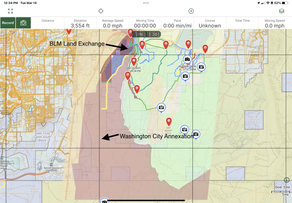
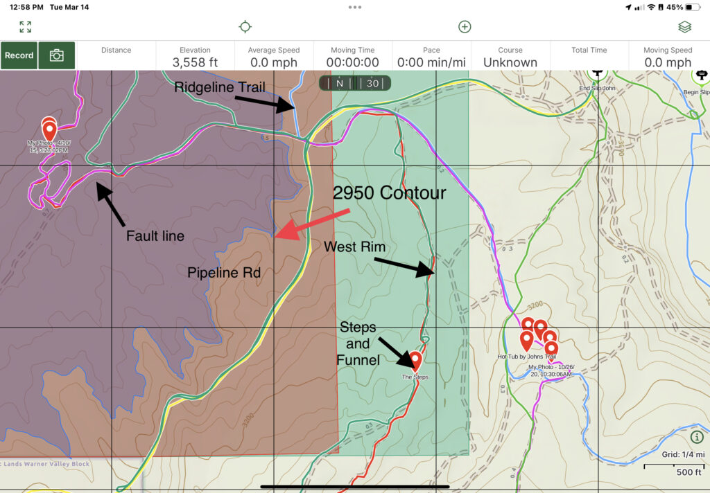
Scoping is underway for the proposed Land Exchange for the Washington County Water Conservancy District to obtain 1050 acres of land from the Western portion of Sand Mountain OHV area near Warner Valley. Part of this is to provide land for the new reservoir, to which we have no objection, but we are in opposition to the addition of the land east of Warner Valley Rim which would affect West Rim and Ridgeline Trails. You can learn more about the details here at www.UtahPLA.com
Recent Development Monday Morning-VERY IMPORTANT
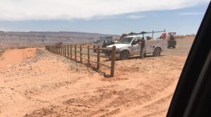
We had a meeting with the Washington County Water Conservancy District this morning to discuss our concerns about losing both access and Open OHV recreation on the area east of the proposed reservoir waterline. We reached an agreement a verbal agreement that WCWCD would stipulate that the area will be restricted against any development activity and that it would remain designated for Open OHV forever, regardless of who might be managing the property. In addition, they agreed to also ensure we have either continued access via the Ridgeline Trail from Washington Dam, or will cut in an alternate access. This was the outcome we were hoping for, and greatly reduces our concerns. We will take steps to ensure this stipulation is well documented. At this point, we still are taking the position to oppose the Exchange until we get further assurance. We need everyone to show up at the meeting tomorrow to show your support,
What is Scoping? NEPA requires the Bureau of Land Management (BLM), to involve the public in the planning process and seek their input through a scoping process, which is one of the first steps of the process. It will be followed by BLM’s preparation of a draft Environmental Impact Statement (EIS), and you will have another opportunity to submit comments. Effective NEPA scoping comments for BLM should answer these questions, some thought starters have been included in italics, but come up with your own questions.
- Provide specific information about the proposed action, including its location, purpose, and potential environmental impacts. We understand the purpose of the reservoir use, but what is the purpose of the large acquisition east and north of the reservoir? We have asked the Water Conservancy District and City of Washington what they plan to use the land for, and their response has been that it’s too early to have thought about it. How will it affect visitors and their economic impact?
- Identify any alternatives that the BLM should consider, including no action, and explain why they would be preferable or less impactful. What other locations may have been considered for the exchange located north and east of the reservoir? Include alternatives in the EIS that eliminate the areas east of the reservoir.
- Highlight any potential significant impacts that may result from the proposed action and suggest ways to mitigate or avoid them. Without knowing what the use will be, it is impossible to clearly analyze potential impacts or mitigations. Some impacts could be things like user conflicts between OHV and development or noise or traffic concerns.
- Provide relevant scientific data, studies, or other sources of information to support the comments.
- Address the scope of the proposed action, including any indirect or cumulative effects that may result from the action. How will access to the public lands on top of Warner Ridge and West Rim be accomplished. What will be the impact of the loss of staging and dry camping in the area? What will be the impact on OHV traffic patterns from the recently constructed Waddy’s Corral Staging area. Why are they taking more land than they need for the reservoir? Where will the people that use the disbursed camping sites on Pipeline Road go to? Where will the campers using Washington Dam free camping area go? There are often many conflicts when different land managers are in charge of adjacent areas, who is going to manage the acquired land, and what is their experience at working with BLM. How will the view sheds from the West Rim trail and above be impacted by the change?
- Identify any potential environmental justice concerns that may arise from the proposed action, such as impacts on low-income or minority communities. How will the loss of free and disbursed camping affect users of lower income?
- Discuss any potential cultural or historical impacts on Native American tribes or other affected communities. What are the potential cultural, anthropological, and historical impacts?
- Offer specific suggestions for how the BLM can address public concerns and incorporate feedback into the decision-making process. Please extend scoping period to give more interested parties time to get more information and make comments. We have a large number of visitors that come at different times of the year, it will take awhile to get the word out to people interested in the outcome.Scoping is not about getting answers, it’s about developing the questions that should be answered in the EIS.
What Do You Need to Do? Attend the Public Scoping Meeting and advise them of the questions and concerns you have. next Tuesday, March 21 from 5:00 to 7:00 at the St George Library, Forsyth Community Room B, 88 W 100 S, St George, UT 84770. Drive your 4x4s, machines, and street legal dirt bikes to show support.
We will inform the media of the event and urge them to cover it, so we urge you to drive your 4x4s and street legal machines to the meeting to show the level of concern about this.
Be respectful and professional. We have a great relationship with BLM in the St George Field Office, and it is very important that you are vocal, but respectful during the meeting. Remember, the media may be there to cover it. It is very likely that the crowd may exceed the capacity of the room, so please be patient. Representatives from BLM will meet with small groups of people at a time. They will also provide Comments Forms to you and help you learn how to submit them. UPLA and DRATS will provide more instructions at the meeting via a handout.
Submit your written comments, these are extremely important, way more important than just showing up at the meeting.
To submit comments, you can do it electronically via either of 2 methods:
- Via email to the BLM at blm_ut_sgfo_comments@blm.gov, with a copy to StopSandMtnSale@gmail.com OR
- Visit Blueribbon Coalition’s Action Alert You can also mail your comments to:
Attn: Red Cliffs/Warner Valley Land Exchange
Bureau of Land Management
Stephanie Trujillo, Realty Specialist
345 East Riverside Drive
St George, UT 84790
Come to the Scoping Meeting on March 21 and Send in your Comments before April 13.
Together, We Can Win,
But We Can’t Do It Without You
 together, along with our partners, the Bureau of Land Management is the way we will win the fight to keep our public lands accessible.